“Dream” route
I’ve been doing some research and have come up with my dream route. Unfortunately I don’t have enough time to do all of, but I might keep it in mind and if I can go away for long enough, and/or walk fast enough, then maybe I can get through it all. (Actually, this is not really my “dream” route, but more my “semi-practical, best case, what I’d really like to do” route. I’m pretty sure my dream route would be way longer and more continuous, with more tourism type stops on the way. But this is what I’d really like to try to squeeze into the time I might be able to get).
Here is a terrible map (sorry about the quality!) of where I’m thinking of going.
 Starting in Glasgow, heading north along the black line:
1. West Highland Way. Milngavie (pronounced “mull-guy”!!, 17km from Glasgow, bus or train) to Fort William. 151km in total. Suggested to do in 8 days. I’ll probably stick to 8 days, but with a side trip up Buachaillie Etive Mor (a big hill).
2. NE along the green line. Great Glen Way. Fort William to Inverness, 117km. Suggested 6 days. Probably do in 4 or 5.
3. North along the orange line. After taking a bus from Inverness to Ullapool, or nearby, I’m planning to walk up to Cape Wrath, via Quinag and hopefully a few other hills on the way (Ben Stack and Arkle, and either Stac Pollaidh and Suilven OR Breabag – these are a long way apart on the same northing so are kind of exclusive if I don’t want to add a LOT of extra distance in). This is the “serious” part of my hiking. No actual track, all relying on my own navigation and mostly in remote terrain with very few towns along the way. As there is no track, I don’t have an exact route and therefore no exact distance but I estimate about 100km. I’ve ‘budgetted’ 10 days for this section.
4. SW along the blue line. Rob Roy Way. After taking a bus back to Inverness then down to Pitlochry, this walk is from Pitlochry to Drymen (on the West Highland Way, 19km from my starting point at Milngavie). 128km, maybe 5-6 days (hilly but all tracks etc so easy walking).
The first and third walk are pretty much definites. The second (Great Glen) and fourth (Rob Roy) are optional. The last especially, I may not have time for.
Anyway, this is a total of 500km of walking and would require ~35 days, excluding flying time but including 2 days off before, after and between each walk. Friends, family, colleagues, dog sitters, voices of reason . . . let me know what you think!
On a side note, I did set my tent up the other day. Inside, because it was wet outside and I need to get seam-sealer to make it waterproof before I bother getting it wet. First impression . . . . I am sooooo scared of damaging it!! It is so thin and light, and slippery! And, I need new tent pegs! Here are a couple of pictures of it. The first is just the inner (yellow). The second is with the fly on. Bear in mind that this is completely un-pegged, so it will look a bit better when taut. No dog for scale as I’m too worried he’ll touch it and put a hole in it! Please note, in the second photo, the bundle of pegs next to it. I have pulled one of the pegs out so you can see it individually. I’d heard the Terra Nova pegs described as toothpicks, and now I must concur. 1g each but I can’t see how they’re going to hold the tent up!!


See the bundle of 13 pegs near the bottom corner, . . . now see the tiny lone peg just below it!
It’s arrived!!
Sooooo excited! My tent arrived today. Look at how tiny this package is . . . less than 2kg all up, and that is not just the tent but also a groundsheet for it, my new sleeping mat AND a pair of sandals that I ordered at the last minute so they could come over in the same package. Wow!!

Sadly, I have to work today so I won’t be able to play with it yet. I have unpacked it all and am currently wearing the sandals though!! And had to make time to share my excitement with all of you!
New Gear: USB Power Adaptor
I recieved my USB power adaptor in the mail on Thursday and gave it a test run this weekend. Happy to say it works and hasn’t blown any of my devices up yet! It is a 4x USB port charger with interchangeable plugs (AUS, UK, US, EUR?). This was particularly useful for me as I could test the device here, then take the UK plug with me when I go. It is a bit heavier than I’d like (~100g) but I think the 4 ports will be worth it. It means that if I have limited time with a power point (e.g. just stopping by a pub/shop/public facility) I can charge most of my devices and my power storage (the solar wraps) all at once. Disappointingly, the UK plug is 6g heavier than the AUS plug!!
Here is a picture of it charging everything up (one of the solar wraps is actually already charged, hence the green light)

I think this completes my set of electronic gear. The full list is:

The only other things are a couple of extras for the camera – a spare battery (I’d hate to run out of power and not be able to take photos for several days) and a special waterproof pouch for it (so I can keep it out on rainy days).
Another perspective on the hike this week . . . .
Steve, my hiking companion, sent this email out about day 2 of our trip. I found it quite entertaining so thought you might like to read it. Plus, it gives me an excuse to put some more photos up! Read below for his summary:
. . . “our walk the other day… when severe weather warnings were posted & bunbury got 52.2mm rain before noon!
Helen found her near-new expensive parka was completely inadequate & afforded no protection at all, and my w/proof overpants of many years use had secretly split down the the crutch seam, as I put them on presumably.
She was soaked to the skin within half an hour and my undies/trousers/legs/socks rapidly became increasingly cold & wet as the rain poured down my back & straight through the split seam of my pants!
We left the night’s hut around 8am & shortly after, decided to abort the walk & bail out, so walked non-stop for 3hrs in pouring rain to Mumballup pub, eagerly anticipating a warm, dry boozy afternoon by the fire waiting pickup by Cherie, rather than continue on & try to survive another 3days with saturated clothes and no rain gear worth mentioning.
Unfortunately the pub was shut, there are no phones there & Helen had no reception on her mobile…. Exit plan A.
So we changed into what extra few dry clothes we carry & sat shivering on the verandah discussing plan B.
After unsuccessfully trying to hitch into Donnybrook we managed to borrow a mobile from a passing truckie and phoned Cherie. About an hour later we were warm & cozy with the car heater full bore & heading home!
Apart from the chill we enjoyed it.
This is why we walk in winter…. Placing faith in your self & gear on the knife edge of “character building” vs stupidity and knowing the difference! “

Directions to the part of the track we didn’t get to.

A Willy Wagtail (sorry about the quality – he ran over the other side of the road so I was at full zoom)

Making ourselves at home on the pub verandah

Another nice shot of the approach to the hut.

Steve and his stove setup. For those doubters out there, Steve will attest to the fact that I didn’t eat/drink anything warmed by this stove! (I did have some of his green ginger wine for warming purposes though. Definitely need to add some form of liquid heat to my gear list!

More pretty flowers

Another lovely section of Bib Track

Steve demonstrating why trekking poles are an essential piece of hiking gear (camp, day 1)

Me on the track (day 1) – you can just see me in the distance
First multi-day hike
The plan was to start from just outside Collie and walk along the Bibbulmun Track to near Balingup, stopping each night at the huts on the track. The walk was just under 80km and would take 4 days/ 3 nights.
For those who don’t know, the Bibbulmun is a 1,000km walking track stretching from Kalamunda, in the foothills of Perth, all the way to Albany, on the south coast. The track has been specifically built for walkers, modelled on the Appalachian Trail with shelters and water tanks every 10 to 20km and routed to provide an interesting walk, primarily on bush tracks, with minimal conflict of interest with other land users. You can read all about it at http://www.bibbulmuntrack.org.au

Waugal marker on Bib Track
I packed the night before, with advice and general banter from Steve who had kindly agreed to accompany me on my first hike (and who has lent me a lot of gear while I’m waiting for mine to arrive). There were lots of “do I need . . “, “how do I . . . “, “what’s the best way to . . . “ questions until eventually everything was in the pack. Total weight of ~14 kg (confirmed at 14.2 the following morning) which is significantly more than I want to carry but acceptable for this first, shorter hike where I have a lot of borrowed gear that is heavier than mine will be.
Please note, I am using the “Steve” pack weight method, which means that total pack weight is everything going on the hike except me. This includes everything I’m wearing and carrying including food and water. The aim is to keep this under 20% of my body weight. We didn’t achieve this, but I’m still confident of getting there for my holiday. Gear list is below. 
Luckily Merlin was too tired from the past couple of days’ activities (see previous blog post) to try to get involved! He slept throughout the entire process then put himself to bed (my bed) very early while Captain and Lucy soaked up the pats and attention.

We set out at about 11am on Monday in glorious conditions. Big thanks to Mum for driving us to Collie.

The track was lovely, the pack was comfortable (although definitely a bit heavier than I want) and the company was good. We stopped at Mungalup Dam for lunch (Subway from Collie, as is Steve’s tradition) then headed onwards.

We saw some interesting flowers and went through some beautiful patches of banksia and sheok bushland, as well as the standard “bush”.


Today’s was a short walk, only 14km and we arrived at the Yabberup campsite at about 3pm.

I managed to pitch the tent (with only a little assistance from Steve), made my bed (sleeping mat and bag) then set myself up for an afternoon of reading (the book was a weight penalty I was convinced to bear, and I think it was worth it for this trip), charging the GPS and having dinner. We watched the stars come out, shared some green ginger wine then retired to bed.


Overnight, our beautiful weather disappeared. Some time during the night it started raining, including some very heavy downpours. At one point my tent felt a little like a waterbed as the entire base was basically floating on water (I discovered the next morning that even after thinking about potential flooding, I’d still managed to pitch in the middle of a substantial drainage route). Luckily there were no holes in the tent base and the rest of it remained waterproof. The same can not be said about the rest of my gear!

I woke up to ongoing rain so very carefully dressed and packed up inside the tent. I moved my pack into the hut then came back and picked up the entire tent and also moved it inside, to give it some chance to dry, and me a chance to pack it up without dropping it in a pool of water.

Packing up the tent in the hut. This is the last photo for a while today as the cameras went into the packs to stay safe and dry!
After breakfast we headed out, with the rain continuing to pour down. Sadly, I discovered at this point that my gortex jacket was not at all waterproof. Very disappointing as it was quite expensive and only about 2 years old. I knew my waterproof pants weren’t 100%, especially at stopping water getting into my shoes. This, combined with the track becoming a raging torrent (or babbling brook, depending on current levels of cheerfulness) and no waterproof jacket meant that I was soaked through, from head to toe (minus some small sections on my legs – the pants were doing an OK job) in almost no time at all. I decided very quickly that the sensible thing to do would be to bail out at the Mumbalup Tavern, 12km away. Steve agreed, as he was also finding things not as waterproof as he’d hoped.
After about half an hour of being miserable (and very annoyed about my jacket) I cheered up and quite enjoyed most of the walk. Unfortunately no photos as we had prudently put the cameras away to keep them safe and dry! I discovered when we got back that there were severe weather warnings for the entire area, with some areas nearby recording 80mm of rain in a couple of hours. The rain was certainly that bad where we were, and there was a little thunder, but at least it was not windy. Probably the worst part (other than the non-waterproof gear) was that the track was several inches deep in water for most of it, sometime even worse, so we were forced to go bush-bashing to get past.
Unfortunately we arrived at Mumbalup only to find that it was closed (the guy simply said he was “not getting up today”), there was no phone, and I had no phone coverage there. At least the toilets were open and we could change into dry clothes.


We tried hitching for a while, then eventually a passing truckie (also called Steve) lent us his phone so we could call home for a pickup. Waiting to get picked up gave some time to play with the camera and my water filter. I’m very impressed with the water filter results and slightly amused by the comparative colour of the water we had been happily drinking!

I poured half the water from one bottle into the other, through the filter. See how much clearer the water on the left is?
Huge thanks to Cherie for picking us up at short notice, although she was more than half expecting it given the weather warnings!!
I’m still claiming the trip as a success as I learnt a lot (and not just about my rain jacket!). Here are some findings from the trip:
Pack: My pack performed well. It was comfortable and fitted everything in. The trampoline back not only allows airflow to keep my back cool but also seems to help stop the pack getting wet when there is water running down my back. I could keep a water bottle on each side which made them accessible, although we are not overly convinced that they won’t fall out. I can also reach into the top (lid) pocket very well – this is a good spot for the camera. The pack is not at all waterproof. I was borrowing a pack cover which worked reasonably well – the top of the pack was slightly wet where the rain was belting down on it but the rest was reasonably dry. Unfortunately when water got in, it pooled in the bottom of the pack cover, making the bottom of the pack very wet. I think I’ll need to put a small drainage hole in the bottom of my pack cover to prevent this.
Shoes: I’m quite happy with how my shoes performed. They didn’t hurt my feet and were not at all unpleasant to put on for the second day of walking. The grip was very good – no problems on slippery mud, gravel or rock, and no honkey nuts getting stuck in the tread. The mesh on top was definitely not letting water in, but I’m not sure if there was some leakage through seams on the sides – my feet got wet quite quickly but with all the other problems I don’t know if this was just coming in at the ankle or seeping in through the shoe.
Sleep Systems: The short (1.2m) Thermarest pad was definitely long enough for me. If I curl up, my feet fit on, if I stretch out my heels are on the ground. I had my pack inside the tent (and glad I did when I looked out to an inch deep pool in the morning!) then my pillow (spare clothes in their dry bag, wrapped in my fleecy jacket), then the sleeping mat, so this gave some extra length to the mat and stopped my ‘pillow’ sliding around. This pad was self inflating foam and quite thin (1cm). It was enough to take the bite out of the small pebbles and ground lumps but I think I’d prefer something thicker (I’m looking at the inflatable Neo Air XLite). This would also help with insulation – with cold water flowing under the tent I really noticed the lack of insulation underneath me (more about this in a future post about sleeping bags). I got too warm, then too cold then one part too warm and another part too cold (etc) throughout the night. It was also a bit unpleasant being sticky, sweaty and dirty. I didn’t really bring sleeping clothes, just a thermal top and underwear. I think getting some proper camp/sleeping clothes will help with these problems. I’m also still looking into a silk liner for my bag, so I can use that like a sheet if it’s warm.
Packing: I had things packed in separate bags – the tent and sleeping mat in their own (non waterproof) stuff sacks and then separate dry bags for my sleeping bag, clothes and electronics. Food was generally in waterproof packaging or zip lock bags anyway so was just loose wherever it ended up. This was a bit annoying so would’ve been better in plastic bags or something to keep it together. Most importantly, everything that needed to, stayed dry. Also, it was quite easy to unpack and repack. Having things in separate dry bags, rather than trying to waterproof the entire pack worked for me. It is important to pack things together that need to be used together though – I think it would be better to pack every-night electronics and clothes in one bag and town/occasional-use clothes/electronics in another, rather than having all the electronics together and all the clothes together. Except where the clothes bag is used as a pillow – the last thing I want is a power adaptor sticking into my ear!! It will require some fuzzy logic, but hopefully you get the idea. I’d like to get a better waterproof pouch for the camera. I had it in a ziplock bag in the top of my pack, but didn’t feel safe leaving it there when it was pouring so ended up putting it in one of the drybags, where it was inaccessible.
Solar Panels: I didn’t try to use these during the walk (too many trees blocking most of the direct light) but charged them for an hour or so in camp, and recharged my GPS logger. They seemed to work well.
GPS Logger: I really should’ve read the instructions more carefully before coming out as I didn’t really know what each type of light flashing meant. Happily, it did work correctly, as you can see from the track log. I think it stores waypoints (or ‘photo spots’) wherever I stop, rather than just when I pressed the button. It was not easy conditions (steep hills, tree cover, heavy cloud) so I’m very happy that it worked so well. Here is the map of our route (haven’t worked out how to display without flags and camera icon yet!). Pink is day 1.

Me: My feet, legs and shoulders held up quite well. I know it was only two half days, but I had done some pretty intense activity the previous couple of days as well and my feet and muscles were all OK to keep walking. My navigation was good. I enjoyed being in a tent in the middle of nowhere and enjoyed the walking. All in all, there were no show-stoppers for my planned trip.
Food: Didn’t really get enough time to test long term requirements properly. Premixed muesli and milk powder worked well for breakfast (with ziplock bag as bowl). 1 bottle of sustagen/milk powder to drink during the day to top up energy requirements worked well (easy to carry the dry powder to make a new batch every day). Eating dehydrated pre-packaged food cold was fine (just add cold water and leave to rehydrate for longer, rather than adding boiling water) so I’m still on target to not take a stove. Special K is a great nibbly during the day. Hopefully will be able to get by on ~0.5kg/day.
Other: A towel is definitely an essential!!
If the weather looks awful, it may be best to hole up in the tent for a day, or take other precautions (sandals instead of boots, no trousers under waterproof pants) rather than getting me and most of my gear soaking wet.
Exit routes can be much more difficult than expected when on foot with no communications.
Pre-hike weekend
A few things came together this week that made it the perfect time to go for my first multi-day test hike. Firstly, there was a rowing regatta in Bunbury on Saturday that one of the girls was keen to enter a crew for. Secondly, there was a 10km trail run ‘fun run’ in Greenbushes on Sunday which my masseuse had been telling me I should enter for ages. The next obvious thing was to stay down in Bridgetown and do a four day hike Monday to Thursday. Clearly racing a pair then running 10km is perfect ‘recovery’ prior to a long hike!! I think it will just help condition me doing weeks of walking.
Unfortunately I’ve got so used to doing things whenever I want that I’d completely forgotten that I said I’d be available (in the office) for the next few weeks so organised the trip without thinking about it. Luckily for me this fitted in OK with work as they wouldn’t have the data I needed until Friday!
The rowing regatta went pretty well. It was a bit cold, raining and a little windy, but much better than most Bunbury regattas I’ve been to. I was racing a pair. The pair is a crazy boat which has two people rowing it, and only two oars. So that’s one oar each. That means that if you don’t pull at exactly the same time or the same power as the other rower, the boat starts turning in a circle (or does little S-bends all the way up the river). It also means that you have very little control, individually, over balance, or anything else for that matter. It is the ultimate in teamwork.

Mackenzie and I in a pair. Pretty crazy boat isn’t it!
My pair partner had never rowed a pair before. I haven’t rowed one in about 5 years, and very infrequently even back then. We did three training sessions during the week, which we were very happy with, but even then were pretty intimidated to be up against some big girls with a lot of experience in pairs (e.g. National Champs, albeit in U19s). We came second in our heat (wow!) and were fast enough to get into the final. We then managed to come third in the final (out of four crews – it’s a narrow course), out of a total of nine crews entered. Very happy with our result and also with the racing and rowing in general.

Merlin and I hanging out at the regatta. I’d already been asked once if his owner was out on the water since he kept staring out there rather than wanting to be with me!
On the way to Bridgetown we stopped off at Barrecas winery to get some wine and have a lovely chat with Kelly. Merlin had a wonderful time running around the olive trees and rolling in the long grass.
The trail run was very hard. I don’t think I’ve worked that hard in ages. For a start, the 10km turned out to be 11.4km. The tracks were pretty good – mainly dirt car tracks and some sections of Bibbulmun track (see next post) on generally gentle hills . . . although a couple of quite steep sections! People keep telling me that I should be able to run 5min kilometres, so I decided to give it a go. Luckily I reminded myself that I wasn’t a “Runner” so didn’t get disheartened when a few girls tore away from me at the start. Instead I just kept running my hardest to try to get my 5min/km pace. It was really hard! It turns out that trying to run 5min/km for 11.4km on gravel hilly tracks with no training (I’ve run twice since March, and they were both with the dog so had heaps of stops in them!) is not such a great idea!
Anyway, I ran it in 47:40 (5:03min/km – so close!!!), 5th girl and 13th overall. Not too bad, and I definitely couldn’t have done much more! On the plus side, I was using my new Scarpa Enduro shoes (for my hike) and they felt good. Also, while I was puffing the whole way and pretty exhausted at the end, I didn’t feel the “flat” tired, fatigued feeling I was getting before Nationals.
One of my friends won the 5km run in a very quick time. I’m classifying him as a “Runner” (capital R) as he’s not really into sport and managed to do that without even training for it!! Good work Russ!

Me, getting nervous (and un-colour-coordinated) at the start of the fun run.
While I was at the trail run Merlin went to the Million Paws Walk, then dog training, with Mum and her dog, Captain. No photos from that unfortunately but from all reports it was a lot of fun. Merlin then proceeded to run around the farm like an idiot all afternoon, including several “swims” in the mud-pool that has substituted for our dam these days.
GPS Logger – i-gotU GT-600
I picked up my GPS logger today (it arrived on Friday but I haven’t had a chance to go to the post office until today). I feel like this is my first chance of doing a proper “review” blog, so we’ll see how I go.
I was looking for a device that could record where I went for ~ 4 weeks without needing to download or upload data on the way. Long battery life was essential (>10 hours at least). I didn’t need any kind of display or ability to actually navigate / use it as a GPS. I couldn’t find anything suitable until a friend put my onto this device. The data is stored on the device so I simply download it when I get home.
Firstly, big thumbs up to i-gotU for providing plastic packaging that wasn’t impossible to get into. Everything was securely held yet I managed to easily get everything out without even resorting to scissors. The package included the GPS logger, soft plastic case, cable, wrist strap, driver/software/manual CD and carboard cover with basic specs and instructions.
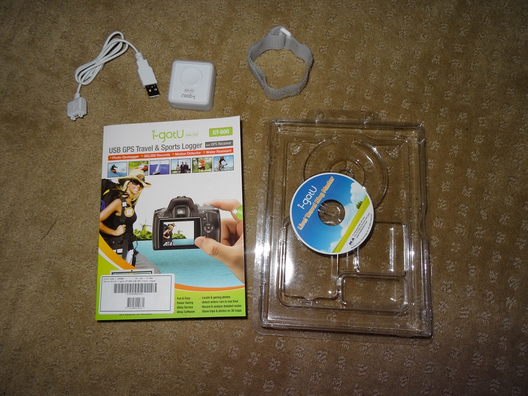
Secondly, thumbs down for not using a standard micro USB connection. Most of my devices now use this (I’m not an Apple person), so I was looking at taking minimal cabling. Unfortunately the GT-600 has some kind of proprietary, or simply not common, connection so I’ll have to take its own special cable (16g for those who are counting).
I’ve just installed the software (device driver and program to manage data and devices), which was provided on mini-CD. Nice to have it provided on a CD rather than having to download, although I understand this can be an additional cost and waste of resources, especially if the software goes out of date and needs to be updated online anyway.
I’m impressed with the options in the hardware setup. Firstly, you can use normal manual on/off control or you can actually schedule the unit to turn on and off at particular scheduled times. Pretty cool, though not something I’ll be using this trip.
There are 6 modes for setting tracking parameters, based around how fast you expect to be. I’m interpreting the icons as: walking, running, cycling, scootering, sailing, driving. Within this you can set the tracking interval (every x seconds or minutes) and can use a ‘smart tracking mode’ which increases the tracking frequency (decrease interval) if you’re travelling faster. Default is tracking every 5s, which gives a battery life of ~30hours. Increasing the tracking interval increases the battery life if power saving is turned on (e.g. tracking every minute gives ~200hrs battery life) so I’m guessing power saving basically turns the device off for the minute between GPS points.

Tracking interval setting screen, showing setting for mode 1 (walking in thongs!).
Circular Logging presumably deletes old data points when it runs out of space (it gives me a message to download/backup data then clear it before changing this setting). I think Button Control stops the on/off button on the device working so I guess it works purely on motion detection – if you’re moving, it’s on. Motion Detection means that when you’re not moving, it doesn’t record so I can turn it on at the start of the day and off at the end and not worry about stopping it at every photo opportunity, meal and rest stop. It should autosleep itself and re-start when I start moving again. If Motion Detection is off, Button Control MUST be on (hence my assumptions). The Advanced window simply asks whether I want it to automatically power on while charging (default set to “no”). Not sure why this isn’t on the main menu with the rest of it.
I’m not sure how I swap between modes. I think whichever one I have highlighted in the settings box will be the one that applies.
This is where it’s important to realise that the logger itself is just a small white box (41g for those who are counting!) with a single button for on/off, a couple of LED lights to indicate on/off, GPS status and low battery and a port for charging / data download. All of the settings must be handled through a computer. This is fine, especially as it probably saves a lot of weight, cost and potential problems, but means I need to get it right before I go. The logger also has a small hole through one corner to attach a lanyard (not supplied).

Logger, showing strange connection, with paw for scale. Merlin is huge, so probably makes this look smaller than it is. I got some photos without him in them, then he got bored and pushed in.
The packaging states it can hold 262,000 records. At a tracking interval of 5s, this is over 350 hours (correct me if I’m wrong – 350 x 60 = 21,000 minutes. 21,000 x 12 (12 samples every minute) = 252,000). This is definitely enough for a 4 week trip, even if I walked non stop for 10 hours a day every day.
I’m planning my first multi day hike next week so I’ll get a chance to test it in some slightly challenging country (hills and tall trees). I’m pretty excited about this device as it is pretty much exactly what I was looking for so hopefully it meets my expectations.
On other updates, my Solar Wrap Mini’s can successfully charge my phone (I’ll try to do some proper timed stats on that in the future). I tried setting up wifi connection between my camera and the computer, then read the instructions and realised I needed a wireless access point (ie router) which I don’t have, so that ruined that idea. I’ll have to stick to connecting with my . . . . standard micro USB cable!!
A busy day for the postmen.
I’d begun to doubt the virtues of online shopping – the excitement of the purchase had faded and the eager anticipation was slipping into despondent ennui. I was still within vendor “expected delivery times”, but outside my optimistic estimates. I’d even sunk to making a spreadsheet to track order date, earliest delivery estimate, latest delivery estimate and actual arrival to curb my desire to chase up the suppliers.
Today I had some relief. Not one, not two, but three packages arrived (four if you count the fact that Angus & Robertson felt they needed to sent my books separately!). I’m not being sexist in the title either, they were all delivered by men – my normal postman, the Aust post parcel delivery guy AND a courier man.
I was trying incredibly hard to do some work today so wasn’t going to tell you about this until tomorrow. Seriously though, three deliveries in one day . . . . .too much! I kept working through the first two, but couldn’t resist when the third arrived.
So, here are my goodies:

The pile in the top left corner is a pile of cycling gear, especially wet weather and windstopper gear for winter. It’s very hard to take photos of with the flash because a lot of it is reflective – even sections that look black were flaring in the camera flash! As inconvenient as that is to take photos, I’m glad it’ll be that bright when I’m out on the roads.
Below that are my solar panels. I’ve got two of the Bushnells Solar Wrap Minis. They may not be much use for solar charging in Scotland but also have inbuilt battery (2200mAhrs) that can be charged by USB and are incredibly light so I’ll be using them mainly for power storage with any solar charging I can get from them as a bonus. Besides, solar panels are cool right? It’s the perfect day today for testing them for my trip (completely overcast and drizzling!) so I have one outside attempting to charge already. I’ll do some proper testing (see how much I can charge from fully charged, and how much power it can get from an hour outside) and get back to you with an actual “review”.
Next (bottom right) is two books I ordered last week. One is “Scottish Highlands: A Hillwalking Guide” which has a bunch of useful information about safety, what to take, what to expect plus some suggested walks and places to eat/stay/go. I know that all of the information is probably online but I’m a little old fashioned in that I still feel like something written down in an actual book is more reliable. It implies that the author is actually serious and knowledgeable enough about his/her subject to write a book, and that someone else has actually checked the information! I also find that sometimes there is simply too much information online. It can be hard to identify which information is most important to me, and I can get lost in the never-ending web of links. Plus, I get sick of being on the computer, so a book is a nice alternative.
The second book is one that I’m very excited about. It is part of a Rock Trails series (Rock Trails: Scottish Highlands) which explains the geology of the area and then suggests some walks to see and explore the key geological features. I’ve started reading it and, while I’d like some more technical geological speak (it’s written for geology novices), it seems to have the information I want. After reading this book I’ll start some serious route planning and probably be able to finalise a few things. For how excited I am about this book, I feel like this paragraph doesn’t have enough exclamation marks in it. For those who don’t know, I love rocks!
Continuing around in an anticlockwise direction we have Merlin, who didn’t arrive by mail today but was determined to be a part of whatever I was doing on the floor. Sometimes it’s easier to work around him than to make him move. I was reading some blogs last night from people who walk the highlands with their dogs. It would be wonderful to take him with me but logistics unfortunately prevent it. Besides the international travel and quarantine, I don’t think I could carry enough food for him and he would most likely destroy all of my lightweight (ie fragile) camping equipment!
