Home » Hiking » 2014 Scotland Trip » Scotland 2014 Trip Reports
Category Archives: Scotland 2014 Trip Reports
Durness-Inverness-Edinburgh-Glasgow-Perth (Saturday – Friday)
I got up reasonably early (8am?) on Saturday morning and packed my suitcase . . . badly. I may’ve been a little tired and hungover from the night before (there was a bit of a bonfire and party on the beach, not in honour of me leaving, just a coincidence).
I had one (well, two) last things left on my list of things to do: take the boat tour of the inside of Smoo cave and walk all the way to the ends of the inlet at Smoo. I had been to and past the cave so many times but just hadn’t got around to doing these yet.
Unfortunately the water level in the cave was way too high to take the boat in, so that was out. Put that on the “next time” list, with Arkle! I did walk all the way out to both ends of the inlet though. Not particularly impressive or interesting but a nice walk and good to see the area properly.

Looking back at Smoo Cave from the end of the inlet. Tide is in.
Then it was a long drive down to Inverness. This is the first time I’ve driven the direct route from Durness to Inverness so I got to see all sorts of places I’d only ever heard of (Bonar Bridge, Lairg). There was a road bike race coming the other way – heaps of cyclists struggling up Scottish hills! I’m glad we were going the opposite way and not stuck behind them!
We took a shortcut (or detour, I’m not sure) along a scenic route, which gave some beautiful views of the valley.

Me, at the lookout on the scenic route.
Then, coming over the Kessock bridge (over the Beauly Forth) into Inverness there was a massive cloud bank. It went from a lovely sunny day, to complete white out half way over the bridge. All of Inverness was covered in cloud! Pretty weird for me, although I think not unusual around here.
We stopped in town for a late lunch then headed out to Scott’s sister’s flat (where we had stayed last time). Scott said goodbye then headed back to Durness (he was working that night). I hung out with his sister, her partner and the kids for the rest of the afternoon, had pizza for dinner then we went out for a “girls night out” in town: Scott’s two sisters, another friend of theirs and her partner (he was a very good honorary girl for the night!).
We started at a cocktail place called Bar One. The cocktails were pretty amazing and the other patrons were . . . . entertaining? My Australian accent was a hit with some people. Then we went to a nightclub called Vinyls. 80s and 90s music with a big dancefloor and incredibly sticky carpet! We had some more drinks (including punch from a fishbowl!) and danced a bit, having a great time. Things got a bit trashy very quickly towards the end (not for us, but for the other patrons) so we left, getting kebabs on the way home (a must for a big night out). These kebabs were nothing like we have at home – you couldn’t pick it up and eat it?!?! Anyway, I swear I ate at least half of mine but the box still looked full! It was HUGE!
Sunday
The following day I packed again (still badly) then we went to Great Outdoors to exchange my gaiters (the top elastic cord had snapped somewhere near Suilven) which the store did with no problems. The kids had a great time running around and playing in all the tents that were set up. Then we dropped by Scott’s other sister’s house to say goodbye, then it was off to the train station.
This was a pretty sad time for me. Durness had been my home and these people my friends and family for the last two weeks and this was the final stage of leaving all that behind. From here I was on my own again.
Still, the train ride to Edinburgh was quite pleasant. I went past many place names I recognised (Dalwhinnie, Pitlochry, Cairngorms) and found it quite amusing to hear “next station . . . Perth”!!

Next stop: Perth! Well, still five more days (and stops) for me until Perth
My hotel in Edinburgh was amazing (Frederick House Hotel). I had found it on special so had an amazing room for only 50 pounds. Wow. It was such a luxury to have my own space and privacy again!
I had come to Edinburgh today for a concert. It was actually a “Yes” campaign concert, but I was going because one of my new favourite bands, Frightened Rabbit, was playing there. I had missed out on seeing them in Perth early this year when the festival sold out, so I was delighted when they posted on facebook a couple of weeks ago that they’d be playing this concert. The rest of the lineup was pretty amazing too – Mogwai, Franz Ferdinand, Amy Macdonald plus some others.
I wandered down Rose Street and went to a restaurant called Essence for dinner. It was quite lovely, but probably would’ve been better with company! Then on to the concert. It was in Usher Hall, which is a stunning theatre. The energy was also amazing. There was so much passion and pride in the hall. I think if you weren’t a yes voter already, being there would almost make you one! Apparently the leader of the campaign (Alex Salmond) and a bunch of famous people (Brian Cox) were also there, so I was in fairly high company . . .without realising it.

Usher Hall, filling up with very passionate Scots.
They played a recording of Caledonia Calling, which I know from an Australian band, Colcannon. It made me cry a little and the lady next to me kindly gave me a tissue. She probably thought I was just so passionate about the vote . . but really I was thinking “I don’t envy them deciding which way to vote but at least they get to live here!! (I have to leave soon)”
All of the performances were really good, with the only bad part of the evening being the stupid couple in front of me who decided to stand up all the way through Franz Ferdinand’s set, completely blocking the view of everyone behind them. Luckily they left after that! The band I’d come to see were good, but seemed a little out of practice with each other – I think the lead singer had just come back from doing solo work in America, so maybe that is why? Still glad I saw them though!
 Frightened Rabbit, in a quiet bit. |
 Now really getting into it! |
Monday
The following morning I had finally packed my bag properly and checked out, leaving my bag at the hotel so I could have a wander around Edinburgh. It was raining. Not heavily, but more than a mist. A constant drizzle that actually made you wet if you were out in it for more than five minutes.
I stopped at Hotel Chocolat for “breakfast” – a salted caramel hot chocolate (“with 72% cocoa chocolate to cut the sweetness a little”) and a chocolate brownie! It was amazing! The hot chocolate was so delicious. I had seen this place on the way to the hotel yesterday and decided that I had to try it. I also had a lovely chat to a couple from Aberdeen who came in, about walking and weather and insects and snakes.
I went for a short walk up the Royal Mile but it wasn’t much fun in the rain. I had been told that the weather in Glasgow was better today and that once the rain sets in here like this it doesn’t change, so I decided to bail out and just go straight to Glasgow (I had to be there tonight anyway, but had been planning on spending the day in Edinburgh before going over in the afternoon.

A dreich day in Edinburgh. The Scott Monument.
I picked up my suitcase and headed for the train station, stopping at a pub in Rose St for a pint and some food (whitebait . . . I’d been drawn in by the baked camembert, but they were all out. They were out of chicken too!). I almost missed my train in Edinburgh when the ticket seller sent me to the wrong platform. Luckily I heard them announcing my train and managed to find the correct platform in time.
When I got to my accommodation in Glasgow (a little emotionally worn out) they told me that they’d been trying to call me since 7am (I’d obviously given them my Australian number) because there’d been a problem with my room and they couldn’t accommodate me. What?!?!?! If I had’ve known thismorning I would’ve just stayed in Edinburgh!
EVERYTHING in Glasgow was booked out. The B&B receptionist tried to find places, I tried, a panicked call to Scott led to him trying to find places too. I was faced with paying 400 pounds per night, or staying 30 miles away at Loch Lomond!! Eventually, after at least half an hour, we found the Tartan Lodge hostel could fit me in, although I’d have to move rooms each day and I’d be in shared dorms (3 bed and 4 bed). Also, it was ~35 pounds per night. A HUGE change from my 50 pound stunning hotel room in Edinburgh! At least it was just down the road so I could walk there. The hostel was quite good . . . but not how I’d envisaged spending the last two nights of my holiday!

The Tartan Lodge Hostel.
I still don’t know why everything in Glasgow was booked out. I also still don’t know whether the B&B was telling the truth about the “burst pipe flooding the room” or whether they just had a regular guest who wanted the room so they made an excuse to kick me out.
I checked in to the hostel, googled interesting bars in Glasgow then headed down to Sauchiehall Street to get some dinner and pass my evening. I started at Variety. The bar was nothing special but it was friendly enough and I really enjoyed their music selection. It was not really anything I knew, but all really good to listen to. I kept myself happily occupied reading the Uni newspaper.
When it was dinner time I headed a few doors up to Nice n Sleazy’s for a burger and White Cinnamon Russians (yum). They are known for their burgers so I tried one. It was on a small bun but very tall – impossible to put in your mouth. This reminded me of an earlier discussion with Scott about how burgers too big to fit in your mouth should be outlawed. I agree – eating a burger with a knife and fork is just not the same experience! Also, the burger was a bit too spicy, and maybe I wasn’t as hungry as I thought, as I struggled to finish it. It was accompanied by the best chips I’ve EVER eaten though – the perfect blend of crunch and soft chip, and salt. YUM!
Nice n Sleazy’s was supposed to have an open mic night tonight, but I could see no evidence of it. I was just about to go home when I went downstairs to use the toilets (ladies toilets in bars in Scotland, and probably the whole UK, are invariably up/down at least one flight of stairs and around a few corners.) and heard singing. It turns out the open mic night was in a separate part of the bar in the basement. I sat down at a very centre table (all the edge ones were taken) and was amazed by the talent on display. There were some regulars doing covers (pretty amazing voices though) but also some original songs. Wow! Some of these guys are really good. In particular, a guy from Berlin (part of a band called Sleepover Station) and a local guy, whose name I didn’t catch. Wow! I ended up leaving at about 10:30! A much later night than I’d intended. On the walk home I passed a guy in a Darth Vader mask playing the Game of Thrones theme song with a piano accordion!! (Here is a picture of him from a few days later)

Darth Vader playing the piano accordian!
Tuesday
Tuesday morning I “checked out” (including having to pay to put my luggage in storage before checking back in that afternoon!) then walked in to town. I stopped for breakfast (waffles, maple syrup and bacon – yum!) on the way.
I walked down to Trongate to check out the opening times for the Sharmanka Kinetic Theatre (later this arvo). I saw a busking Latin band who were pretty good, and looked like they were having loads of fun, which made it so much more enjoyable to watch them.

A very enthusiastic (and quite good) Latin band. The base player loved shouting “Tequila”!
I also saw some human statues, all painted black. The first time I saw them I thought they were actually statues! I saw them later today with their masks off too.

Human statues (long-ish shutter speed – see how the woman is blurred but they’re still sharp?)
I went to the Lighthouse. It is not actually a lighthouse, but an old tower building that used to house the newspaper. It now has a Charles Rennie Mackintosh display and various other exhibits including a huge Commonwealth Games exhibit and a very interesting exhibit of different building materials. I even went right to the top of the tower – lots of stairs for an interesting but not particularly visually stunning view of Glasgow.

Looking up the Lighthouse tower.

One view from the top of the Lighthouse.
Then to the Sauchiehall Willow Tea Rooms for lunch, and some gift buying. This is another Charles Rennie Mackintosh building (or at least the interiors are based on his designs and the gift shop is focussed on him.) Charles Rennie Mackintosh was a Glasgow architect and artist, mainly in art deco style.

The Sauchiehall Street Willow Tea Rooms.
Then back to Trongate to the Sharmanka Kinetic Theatre. This is a collection of moving sculptures made from scrap materials built by a Russian artist who ended up moving to Glasgow in 1993. You can go in and see all the sculptures (not moving) for free whenever the gallery is open, but it is definitely worth paying to see a show if you can. This goes through a selection of the sculptures, turning them on individually, with choreographed light and music. It is quite lovely. Whimsical and poignant, dark, sad and humorous. It is genius and incredibly well presented.
After this I went back to the hostel to check in again, then back into town for dinner. I had decided to try the Pot Still, but when I got there it was absolutely packed (I thought I saw signs for a baby shower?!?!?). There were no tables so probably no chance of getting food. I was pretty low on blood sugar (getting a bit shaky) so I needed to find something fast. The second place on my list had been Hairdressers, but they didn’t do food and the place over the road (Stereos) only did vegetarian food, which I didn’t feel like. I didn’t have time (or energy) to look around much more so I decided to go to a place I knew – The Butterfly and Pig (mum and I had dinner there a few years ago).
I ordered straight away (Sea bass plus mash and salad, and a cider). The meal was delicious. I followed up with Sticky Pudding for dessert and another cider. The ciders on the empty stomach did hit me a little!! I read The Times newspaper tonight – reading the paper is a great way to keep occupied when eating out alone.
They also had an open mic night here tonight. They were setting up, but no takers yet, as I was leaving. I didn’t bother staying as it had not been anything special a few years ago when we saw it, and I wanted an early night. Interestingly though, the host was playing some classical music on his guitar just before I left which I recognised as a piece I play on the piano (Bourree). Not what I expected to hear on guitar in a pub in Glasgow!
Wednesday
On Wednesday I got up, showered and repacked for the final time, then took the bus into town. I’d walked every other day but didn’t think my luggage would like being wheeled that far! I put my luggage in storage at the main bus station. This ended up being a real pain. They said my suitcase was too wide for the storage lockers so I had to take some stuff out. Then I decided to put stuff from my daypack into the locker too so I wasn’t carrying it all day. Sadly (stupidly), as I was doing so I dropped the small bowl that I had so carefully carried all the way from Loch Ness Clayworks near Drumnadrochit! I thought it had escaped unscathed, but found out later that it had quite a large crack and a crushed section on the edge. Grrrr. Very unhappy with myself and the luggage storage guards (not their fault, but it helped being angry at someone else).
I had breakfast at an Italian sports bar (weird, I know, but nice enough) then went for a walk. I was still pretty upset about leaving and needed to walk, . . . and walk and walk and walk! I walked all the way out Sauchiehall Street through Kelvingrove, admiring the fountain on the way.

Stewart Memorial Fountain (I think) in Kelvingrove Park.
I decided part way out to go and see the newly restored bandstand – it had been in a terrible state last time I was here but I’d seen an article on its restoration in the Lighthouse. It looked amazing, but unfortunately was all fenced off so I couldn’t get a closer look.

The Rotunda – refurbished.
I then remembered that last time I was here, Mackintosh house had been closed so we’d been unable to see it. This is a recreation of the interior of Charles Rennie Mackintosh’s house (and his wife, Margaret Macdonald). The original house was about 100m away but was demolished due to stability problems, probably due to old mine workings! All of the furniture and fitting were put in storage until finally he was famous enough that someone decided to recreate the house.
I walked up through Glasgow Uni to get there – there were heaps of students out handing out stuff for Freshers week . . . I obviously don’t look like a student anymore as nobody tried to give me anything! The house is open by guided tour only so I bought my ticket then killed time waiting for the tour in the adjacent art gallery. They had a Whistler exhibition (American painter) and an exihibition of Scottish landscape painters. It really made me wish I could paint like that so I could capture my essence of the hills and countryside.
The CRM house was pretty incredible. The whole house is ‘designed’! I don’t know if I could’ve lived in such a formal, uniformally motiffed place! I guess it was their stuff, and the style they loved though. I loved the tall mirror in the bedroom, but otherwise it was all so ‘set’. Don’t get me wrong, it was all amazing and beautiful . . . just not the style I’d like to live in! The tour guide was very informative and it was an interesting window into Charles and his wife’s lives, complimenting everything I’d read in the Lighthouse. It seems like him and his wife were really good together. I do wonder why he stopped designing buildings though.
From here I walked to the Exhibition Centre, thinking it was the amazing looking building designed by female Iraqi architect Zaha Hadid. Unfortunately, I got my buildings mixed up and Hadid’s building is actually the Riverside Museum!! The Exhibition Centre is not so exciting to look at (although it is big and Sydney Opera House-ish), but does have a group of interesting structures nearby including the Rotunda, BBC, SSE Hydro Stadium, Clydeport (Finnieston) crane and the Squinty Bridge.
-

- The Clyde Auditorium at the Exhibition Centre (nicknamed the Armadillo I think). I don’t know what the “Exhibition Centre” actually was – I thought this was it. Maybe it’s just the whole area?
-

- The BBC
-

- Clydeport crane
-

- SSE Hydro Stadium
-

- The Rotunda
-

- The squinty bridge
More walking, back along the river to the middle of town (I still needed some more walking to clear my head) then up to the Buchanon Street Tea Rooms (the sister to the Sauchiehall Willow Tea Rooms) for lunch. I was, coincidentally, seated at the exact same table that I was at with mum two years ago. This made me smile. I had the high tea, the same as last time, which was absolutely delightful . . . especially the scones and jam and cream, and pecan cheesecake!

High tea at the Buchanan Street tea rooms . . at my “usual” table!
After that, back to the bus station (with a stop at Tesco’s to get extra food for the plane), past more street performers, then out to the airport. Again, this was a very sad time for me. I felt more like I was leaving home than I was coming back to it.

A tightrope fiddle player (although the rope isn’t very tight!). The previous day he’d been wearing a kilt!! Pretty daring on a tightrope!
On the way to the airport we went past a huge “Yes” demonstration. A bit of a word on the referendum drama. . . . when I had arrived here, there were a few Yes or No posters, and maybe a couple of people with badges or shirts on. By the time I left, it was crazy. A lot of houses had yes or no posters and flags in their windows and there were people campaigning everywhere. In the countryside, huge “Yes”s would be painted on fields or buildings. I say “Yes’s” because the Yes campaign was a lot more vocal, . . . and a lot more aggressive about it. There were even stories of Yes campaigners pulling down No signs and replacing them with Yes, smashing windows that had No posters in them and painting “Yes” on No supporter’s houses. It was pretty intense. The escalation was very obvious, and surprising, to me as I’d spent the intervening weeks in Durness where it was all relatively low key (you just had to be careful about what you said around certain people!). It was certainly a very contentious issue, with strong beliefs and passions on both sides.
My trip home was fine. Almost all of my flights were about 30 minutes late, but I had enough transit time that this was not a problem. As mentioned in a previous post, the last flight (Malaysian Airlines from KL to Perth) had all sorts of weird complications, but ended up being OK, if a little late. All of my plane companions were pleasant enough, although I didn’t really talk to them until the very end when I ended up talking to an older man who was returning home to Perth from visiting family in Egypt. I did get a bottle of Amarula in Amsterdam which helped me through the sadness of leaving and the long flight to KL!

Me in Amsterdam to the duty free salesperson: “Oh, don’t worry, . . . I won’t be trying to take it on the plane from KL to Perth”
Friday
Perth greeted me with a hot and bright sunny day. This did not help my mood. All I really wanted to do was go back to Scotland. It was great to catch up with friends and family again, and lovely to have Merlin back. He was very happy to see me, and lay across the door of his foster home so I couldn’t leave without him!

Merlin, making sure I couldn’t leave without him.
Still, I was not excited to be back in WA. I have lived here for a very long time now and it was all so familiar. Plus, I was reminded how much I didn’t want to be living in the city. Everything was rigid and ordered and structured, controlled . . . nothing like the wildness of the Scottish hills.
My holiday was amazing. I had such a wonderful time. Even though things didn’t go perfectly, and there were parts that were downright miserable, . . . I still enjoyed myself so much. Most of all, I felt like I was at home there. Rather than getting Scotland out of my system, this trip has just made me want to go back even more.
Still, I know that things always seem better on holidays, and that I’ve only been to Scotland in summer, and not in the long, cold, dark winters! I keep reminding myself of those things, and making sure that I appreciate every good and beautiful thing that I have here in Perth. I’ve gradually settled back in, cherishing the things (and people) I love around here and trying to appreciate and make the most of how amazing Perth, and Western Australia, is. And don’t get me wrong, it is a wonderful place to live.
However, this trip has made me realise that I want to change some things in my life. So, stay posted. You may not hear about them immediately but I’m looking at the world with a fresh outlook so who knows what exciting things I may come up with!
I know this is an incredibly long, and not that interesting, post to finish on so congratulations if you’ve made it this far. Thankyou very much for sharing this journey with me and I hope it’s given you at least part of the joy it gave me.
Just a reminder for those who joined in late, or want to revisit part of the journey, I have put links to all of the posts, in order, on my 2014 Scotland Trip Stories page, which you can access through the top menu. I’m also going to gradually upload some additional photos, with links to them from these page.
Durness / the Cape (Friday) – ~20km walked
Today was my last full day in Durness. I had been told that the cliffs at the northern end of the Kyle of Durness, on the cape-side, were worth seeing so I decided to take the ferry over and walk up to them. I could’ve gone on my way back from Kearvaig on Tuesday but missed them when I decided to catch the bus home. This would allow me to “finish” the walk back from the cape and give me one last day of walking around bogs and moors.
I walked out to the ferry in the morning and took the ferry over to the cape side (11am). I then walked along the road down the Kyle to just past Daill where I managed to find the track that heads north east up the coast (the road goes north west from here to the lighthouse).

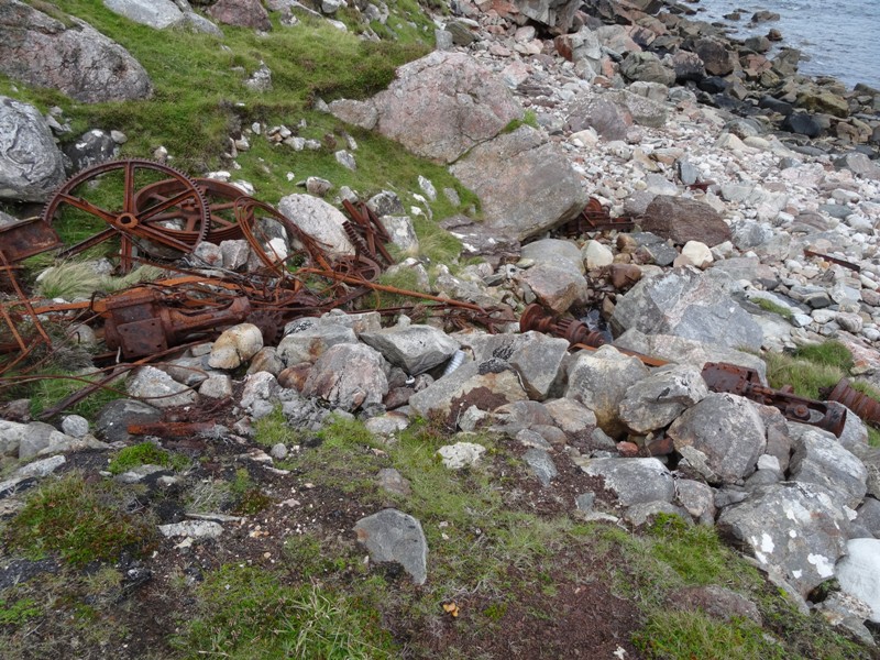
Military buildings on the cape, between the ferry and Daill

Daill, with Fashven in the background (I think). You can alse see the bus (white speck) heading up the road to the lighthouse.
The track was . . . . “OK”. It would’ve been awful if everything wasn’t so dry at the moment! There were some lovely streams and half a bridge, which was funny as I had “F” marked on my map. “F” actually means “ford” but it could equally be interpreted in this case as “half a footbridge” (FB)!

Half a bridge!
I went up as far as the track goes, to an old building. There were some very interesting rocks here, and some parts where the water was swirling around the rocks in a very interesting way. I could’ve sworn there was an animal making the ripples but I watched for a very long time and it seemed to just be the waves bouncing off the rocks and, presumably, more rocks underwater that I couldn’t see. I didn’t see any amazing cliffs, but it was a nice enough walk all the same.

The building at the end of the track. Faraid Head in the background (you can just see the military control tower, “the Bee”, on top)

30x zoom of the Bee.
I walked all the way back to the ferry, just in time to catch the next set of ferry runs at 2pm. I was pretty sad on the way back, saying goodbye to my beloved heather and moorland. The tide was coming in, which led to some very interested cross-hatch wave patterns in the shallows. The Kyle is very tidal – it goes from almost dry (you can walk across some sections but there is sinking sand so you need to be careful) to reasonably deep.

Cross hatching waves as the tide comes in over the sandy shallows.
Back on the Durness side, I started walking back towards town. I had planned to walk to Balnakeil via the Old Manse Track which heads off through a paddock from the main road about halfway back into town. A lovely couple offered me a lift which I took, up to the track, telling them where I was planning to go.
When I got to Balnakeil I stopped in at the Craft Village, looked through a couple of stores then went to the chocolate shop, Cocoa Mountain. I’d heard about it, so wanted to see what it was like. I had a hot chocolate which was amazingly decadent and a couple of chocolate truffles. The couple who had given me a lift part of the way were already there, finishing their hot chocolates. Since I had told them about the place they’d obviously decided to come down and check it out!

Sugar overload! Hot chocolate and chocolate truffle at Cocoa Mountain.
After finishing my hot chocolate (and feeling a little bit over-sugared!) I walked back into town and had a look at the tourist information office. There was a wealth of information in there about local flora and fauna, traditional yearly activities in the area (a board for each month with the activities that traditional farmers would do then) and, . . of course, . . . rocks! Including a bunch of big rocks outside that were all labelled. While most of the northwest is quartzite on sandstone on gneiss (or some combination of these), there is a strip of limestone down the middle, particularly here at Durness and where I was at Breabag. But, it’s not that simple. There are heaps of different rock types all mashed together and mixed up around here. The geological map was pretty complicated!
I spent the rest of the afternoon chatting to Scott and his parents and cleaning my gear up, ready to pack and leave the next day.

And now for some gratuitous dog photos from Wednesday!

Kyle enjoying his time on the beach.

River posing on Aodann Mhor (Faraid Head, and the Bee, in the background).
NW walk Day 9 (Thursday) – Foinaven (24.5 km)
Yesterday was a relaxing day off, but also a little sad with some planning for my imminent departure from Durness. This included booking accommodation in Edinburgh and Glasgow and checking train and bus timetables. I walked the dogs – both of them to the beach, then River out to Aodann Mhor (a point on the eastern side of Faraid Head). I was going to walk River first, but Kyle looked so upset when I was leaving that I capitulated and took him out first! I also managed to try re-waterproofing my shoes, do my washing and hang out with Scott for a while.
Thursday was my last big hill walk. There was only one hill from my original walk plan that I still hadn’t done: Arkle. My plan had been to go to the summit on Arkle, backtrack a little then head over one end of Foinaven (not the summit) then drop down into the valley to continue my walk. However, I had since discovered that you can walk along the entire ridge of Foinaven, going up at the northern end and coming back down the southern flank of Arkle (or vice versa). Foinaven is bigger and more impressive (Arkle is like its little brother) but is not mentioned in the walking books as much as it is also harder to get to, and a trickier walk. Since these were not a problem for me, I was quite happy to sacrifice Arkle to walk the Foinaven ridge instead. Plus, I thought I might have time to get out to the summit of Arkle on the way home as well.
Scott’s cousin’s husband (who dropped me off in Blairmore on Monday) had climbed Foinaven from a start point just north of Rhiconich so I’d organised for him to drop me off in the correct place (it is about 1km north of Rhiconich on the A838, next to some buildings where the river from Loch an Eas Ghairbh crosses the road). Apparently this is where many locals start the walk – the other common start place is at the Gualin (“goo-lin”?), with a long walk in up the Dionard (“dyoo-nard”?). That last sentence is partly to give you a feel for what is was like for me when I started talking to people about where I should walk in the area!

Looking back from the waterfall at my start point.
It was a stunning morning when I set out – clear and dead calm, with all the lochs completely glassy and reflecting the hills around them. It had been like this quite a few times when I’d been driving around but I was always unable to take photos as I was in the car. Finally today I was out walking through it! I made up for all the other days by taking heaps of photos and they are almost all stunning! Unfortunately I was heading east, with the sun just coming over the horizon so it was still a little difficult to take photos!

Foinaven, reflected in Loch na Claise Carnaich
I headed east from the road, along the stream and up the waterfall to Loch an Eas Ghairbh then continued east to go across the north end of Loch na Claise Carnaich (below Lochan Cul na Creige). My navigation was not great, drifting too far south and having to walk up and around the end of the loch – possibly because the sun was a little south in the sky and was dragging me across a bit? It was not that easy to navigate with the lumpy ground being too high to see over, but too low to register on the map (so you couldn’t navigate from it).
It was a little bit boggy here, especially around the lochs and streams, and there were a few midges (being so calm and warm) but it was not too bad.
Then it was up the long spur to Ceann Garbh, the northern peak of Foinaven. It was not too steep or difficult walking but was still super hard work! I had to stop and rest a few times, using the excuse of turning around to admire the view! I had some good views from here of where my original route would’ve taken me. It looked like it would’ve been an OK route.

One of my rest stops (looking west at Loch na Claise Carnaich)
There are some underground streams here – it looks like solid ground but you can hear the water running underneath, and obviously you can sometimes fall in as I had been warned to be careful of them. I think it must be where the ground is actually rocky scree underneath (with big gaps in it) but enough dirt and plant has accumulated on the top that it looks like normal ground.

A portal to an underground stream (this was actually on the way down)
And of course I saw deer (they are everywhere . . . but I still hadn’t got over taking photos of them!)

Deer on the north west slopes of Foinaven
I got to the top just north of Ceann Garbh and made a stupid map reading mistake, thinking instead that I was south of it. I went north and climbed up a pile of rocks on the end of the ridge. It was worth it anyway, but was a silly mistake as the directions and distances were all wrong compared to the map.

My little pile of rocks (looking north east)
I walked back south to Ceann Garbh (realising where I was), then it was a bit of a long walk (~1km) to the highest peak, Ganu Mor. This was a good peak with great views, although it was very hazy. The walk here had been nothing special though.

The real Ceann Garbh, on the right. The short flat section further back in the middle is Ganu Mor
Now it was onto a proper ridge walk! This was pretty narrow, with lots of boulders, but generally not too difficult. This took me up to the peak at the start of the A’ Choir Ghorm ridge which sticks out to the north east of the main ridge. I tried to walk out along this ridge (I like to go all the way to every end of wherever I am). I got a little way along and the path almost completely petered out. The ridge got very narrow and precarious, with just loose, sliding scree off the edge. You couldn’t really walk on top of the ridge anymore (it really was a ‘knife edge ridge’, without even the usual foot or so of flat ground on top), and instead were scrambling and sliding a couple of feet down one side. After a few hundred metres (which took about 10 minutes!) I realised that there was no way I could walk out and back on this ridge at a safe speed and still get down to Achfary in time for my lift home. There was also an outcrop section ahead that looked quite difficult. There was a reasonably high likelihood of slipping and falling, probably without major injury, but possibly enough injury (or just general bruising, grazing and pain) to make it impossible to walk out. Again (like when I bailed out near Stac Pollaidh), I wasn’t willing to be “that person” who had to call out a helicopter to rescue me!
Slightly disappointed, I turned around and headed back. The return walk was difficult enough that I was completely happy with my decision by the time I got back to the peak! I still want to get back out and do this full ridge at some point in the future though!
This was an interesting section as the ridge is actually not that high up. The ‘ground level’ here is quite high, and the scree has filled in the valleys a lot so while it is high where I came up and off to the west, looking to the east it’s not that far down.

The ridge I couldn’t walk out along. See how shallow the valley is.
The next section of ridge was not as bad as the one I missed but still borderline climbing rather than walking! The path was not clear either and, much like the previous ridge, I wasn’t sure (from looking at it) if it was actually possible to get all the way along. However, I’d been told I could (and I had to get through to get picked up!) so I had to find a way through somehow! So, I scrambled and climbed and backtracked (when I found myself on top of a cliffs, with no way forward) . . . . . .

The section of ridge I did walk along!

Looking back (north) at a part I’ve just traversed. There was lots of backtracking coming off the high part as I kept trying to stay on top of the ridge, where the cliffs are, while the “path” is actually a few metres below the top on the western (left in this photo) side.
It really was a stunning ridge line. This is an amazing mountain.
I was climbing (hands and toes, up an almost vertical pile of rocks) . . . . then suddenly I was on top and there was a massive, gently sloping plateau spread out in front of me!

Somehow I went up here: the last climb on the ridge before . . .

The huge flat plateau that greeted me over the top.
I walked south a little bit further to see where I’d been planning to descend on my original route. Nope, wouldn’t have been able to descend off there!! It was very steep and loose, blocky scree. Then I went back up and across east to the last high point (An t-Sail Mhor) to complete the ridge walk then south, down the main spur to where Foinaven joins Arkle.
The main spur looked a little boggy so I ended up following the quartzite outcrops down along the edge of the corrie (west side of the spur). I was walking on the side of smooth slabs of steeply tilted (~30o+?) quartzite! Luckily it wasn’t wet or they would’ve been really slippery. I think I found some glacial scouring here too, where the glaciers grind gouges into the rock as they’re slowly sliding down the hill.

I walked on the smooth sections of these tilted quartzite slabs (the photo is level – I’d found the level indicator in my camera by this point!)

The outcrops I was following down. Arkle in the background.
I ended up coming off the spur right at the head of the valley (south west of Loch an Easain Uaine), instead of much further south east like I’d planned. I’m glad I did though as it suddenly opened up into a stunning section of burns, lochs and outcrops (burns are small streams)

The beautiful saddle filled with lochs and streams (and bogs).
I had a good wander around, including going to look over the edge to the north west. This section would definitely have been descendable, and would’ve led straight onto my planned route so hopefully I would’ve been smart enough to use this as an alternative if I’d still been doing my original walk. I also got a bit complacent at this point and stepped straight into a bog with one foot!

Looking north off the saddle at Loch an Esain Uaine. Arkle on the left, Foinaven on the right.
I followed the edge of the valley and the quartzite outcrops up onto the flanks of Arkle and up to the first ‘mound’ on Arkle (Meall Aonghais), and walked a little north to look over the An Garbh-Coire from the col (if that’s the proper use of that word!). I had already decided that I didn’t have time to go all the way to the summit of Arkle so was taking my time here, then started my descent.

Looking down An Carbh Coire from the col. A beautiful view of Foinaven showing the gneiss-quartzite contact.
I saw a couple of other people here – we actually crossed over paths as they started on the western side of the spur and went over to the east to descend there . . . the opposite to what I was doing!
The descent was pretty tough on my knees and ankles. It was really rocky, although not too bad. The previous 5 hours of walking across this stuff had taken its toll though! It was not too boggy either – this whole area had been pretty dry.
My guide books only have instructions for going up Arkle from here, which are “walk up the road until you see (something) and then turn and head up the ridge”. Going the opposite way I didn’t really know what I should’ve been aiming for but I think I ended up hitting the road pretty close to where I should’ve turned off it (going the other way). I was pretty happy with that!
From here it was a very pleasant road walk back to Achfary. There is a short section of forest with two “erratics” (giant boulders left randomly behind by glaciers) on either side of the path on the way in (there is a good campsite here, clearly used before but otherwise ‘wild’).

Erratics
The rest is mainly through open countryside past old buildings and existing houses.

An old building (called “Lone”), with Arkle in the background (again, note the gneiss-quartzite contact) and some pretty cloud formations.
I saw some cut peat, stacked up and drying, some shooting targets (deer shaped) and a guy walking towards Arkle with a proper full hiking pack (he looked like he was long distance hiking). As it was late in the day, I assumed he was going to camp soon (probably near the erratics) then tackle the hill tomorrow.
-

- The other hiker.
-

- Cut peat.
-

- Deer targets.
I got back to Achfary just in time for my lift home with Scott’s cousin, much more enthusiastic and energetic than I had been after my last walk here (Ben Stack). I got to see an amazing aurora photo that the estate foreman had just had framed, then it was back home to Durness and to the Smoo for dinner. While there I got to chat to one of the locals I’d got to know, who had finally managed to identify the deer ked for me (see my post from Ullapool), sharing our enthusiasm for Foinaven and some of the other hills in the area!
Today had been quite warm, still and a little humid. I made sure I put my suncream on! On top of Foinaven though the wind picked right up and it was actually quite cold. I almost had to put my jacket on! I took my proper Osprey hiking pack with me today, rather than the backpack that I had used for other daywalks. It was still packed pretty light (no tents, sleeping gear, spare clothes) but it cinched down really well and was comfortable and stable with no squeaking, rattling, shifting despite being almost empty. I was very happy with it.
Foinaven is an amazing hill and ridge walk and this was a fantastic walk to end on. I love “through” walks, rather than “there and back” so being able to start at the north of Foinaven and get picked up at Achfary was great. I also love ridge walks in general – one slog to get up high then a long time of wandering around on top! It is also a very tricky walk, keeping things interesting, and the views are good all the way along. Foinaven is almost entirely quartzite (the northern peak is gneiss) so it’s not easy walking but this is what gives it such character. I’m very glad I chose to walk across Foinaven rather than just doing Arkle to complete my original list of hills . . . . but I will have to come back and walk Arkle in the future!


NW walk Day 8 (Tuesday) – Kearvaig to Durness (~25 km walked)
I had a really good sleep and it was lovely to be able to get up and walk around in the morning! Normally in the tent getting dressed and packing up was all done sitting down and there was never much hanging around once I was up and about outside the tent. There were even some deer on the hill outside my window!

The view out my window thismorning. There are deer on the hill, although you probably can’t see them.
I had a very leisurely pack up, including a quick clean up and sweep out of my side of the bothy. Everyone else was still asleep (or at least in their beds) except for one of the kayakers, who I waved to as I headed across the hill towards the cliffs on the coast.

Looking back at the bothy and various tents and kayaks.
These are the highest cliffs in mainland Britain. They are pretty awesome. There was one section that was incredibly smooth – like a huge slab had broken clean off!

Very smooth and sheer . . but no big piles of rocks at the bottom??
Other bits were very jagged, or had cut deep back into the shoreline.

Impressive cliffs. (The highest ones are those really sheer vertical ones near the back I think)
There were hundreds of birds (mainly gulls, but some fulmars and other things), often nesting in the cliffs.

Seabirds nesting on the cliffs (still haven’t found my British Wildlife book so I’m not identifying them properly for you!)
There is a wall along the edge of the cliff. I walked on the cliff side for most of it, but it got a bit narrow for me in some bits!

A very narrow gap to walk between the cliffs and the wall!
There were also sections were the wall looked like it used to continue straight across what was now a crevasse. Evidence that the cliffs are not too permanent!(They are mainly sandstone I think).

Did the wall used to go across this gap?
I also found a cigarette lighter right on the very edge of the cliff. It was a bit rusty, but still worked. Your guess is as good as mine as to why someone put it there.

The cigarette lighter I found.
The other great thing about the cliffs, beside the views and general excitement of being up high, was that it was not at all boggy near the edges!

Right next to the cliffs is firm ground. A couple of metres away is . . . bog!
I followed the cliffs around the coast until I got past the highest ones then cut back downwards towards the road. It was a bit boggy in patches. OK, more than a bit!! It was still not too bad because, as mentioned yesterday, everything had dried out a lot, but would’ve been almost impassable if it had been raining I think. It did rain a little thismorning, but just a very light shower.
I walked down the road to a small building, at “Inshore”. As I was approaching a guy walked out the door with a big gun! He saw me, said something about “tourist” then went back inside. A couple of other guys came out and we had a chat. I thought they were military, but found out later they were stalkers.

Inshore. See the guy at the door . . . with the gun!
From Inshore I headed south to the biggest hill in the immediate area, Fashven. The easiest way up Fashven is to come up the ridge from the south-east. I was currently due north of it. The area around here was really boggy. Not all big black bog, but all wet and squelchy with lots of streams running through it. I was not interested in walking several kilometres through this stuff. I haven’t mentioned it much recently, but this stuff is still really hard walking. Not as hard as Glen Roy, but still much harder than walking across a field or through the bush back home. I was also a lot more comfortable with the Highlands terrain and had started looking at hills recently and thinking “oh, I’m pretty sure I could get up that bit too”. Fashven is a reasonably small hill so I decided it was a good opportunity to put my judgement to the test. So, I went due south and headed up the most direct, and really really steep, bit!

I was aiming for the scree section where the arrow is. Much steeper than it looks!!
Oh so steep . . . . and oh so long! I had to stop and rest several times before I even got to the steep rocky bit. Going up the last bit, the scree got a little bit slippery so I decided to go up the rocky steeps to my right. Again, these were steeper than they looked. So steep in fact that I was practically climbing, with hand holds and toe holds up an almost vertical rock face with my pack dragging me backwards off the rock face! It also still had lots of bits of loose rock. I knocked a rock off part way up and I think it bounced down about 30m before it stopped! I decided that this was not a good idea, so made for a shallower section of slope and eventually got to the top of the ‘cliff’. Sadly it was still a few hundred metres of surprisingly steep walking (with several rest stops) to the summit! OK, so that was a lot harder than I thought it would be. Definitely doable, but hard!

Looking down from the top of the steep bit of Fashven (not the actual summit). Inshore is on the far left, next to the loch.
The summit was not that interesting – big and wide, so not good for views. Plus, the weather was coming in (hazy, low cloud and rain), which ruined the views even more. It was also very very windy up there, so quite cold.
I headed back down the much gentler eastern ridge. Again though, I didn’t want a long walk through the bog so headed north sooner than I should’ve and ended up having to butterfly my way down (flit from side to side) off several outcrops. I was having fun though!
I saw a stalker coming up towards me, and had a chat with him when we met in the middle. Apparently two stags had been watching me from above as I was coming down. There was also a bunch of hinds on one of the other hills. He lent me his binoculars to have a look but they were so far away I still couldn’t make them out. He said there are also eagles nesting on the Fashven, but he hadn’t seen them lift off when I came down so we didn’t see them.

The stalker (full 30x zoom and cropped)
After he checked which way I was going so “he wouldn’t get in my way” (I was more worried about it being the other way around!), we parted ways. It was quite tricky getting off the hill because I still wasn’t clear of the outcrops and had to pick my way around quite a few, with some short precarious sections of descent. Then it was back to the road. The bogs were not too bad for the most part.
On this section I also came across an interesting selection of military debris and more signs warning me to “not touch any military debris as it may blow up and kill you”. Yes, that’s actually what it said!
-

- A very honest sign.
-

- Sand bags for military ground exercises.
-

- Green smoke
-

- Me: “Scott, why is there a pink bus on the range?” Scott: “We don’t have a pink bus!” (outraged at the suggestion) “It’s a desert camouflage armoured personnel carrier” Me: “Oh, so it’s an armoured pink bus?”
-

- More old vehicles
-

- Another old vehicle
I walked east along the road back towards the ferry to Durness and flagged the bus down as it came past. Luckily there was one seat left!! This meant I could get the 2pm ferry, rather than walking out and not getting home until after 5pm. Just so you know, the ferry is not a ferry in the traditional sense. It is more a dinghy!

The “ferry”! (across the Kyle of Durness)
I chatted to a couple of the tourists, who later offered me a lift back into town. I declined however as I wanted to walk along the coastal path down the Kyle to Faraid Head then back into town. One of the other tourists walked with me. Actually he asked if I knew the way to which I replied “no, not really, but I think there’s a path and it’s just up the coast anyway. Pretty sure I can find it”. He was English, holidaying (by public transport) around Scotland “before they become independent”. Not sure what difference that would’ve made to him being able to holiday here?
The walk was much longer than I thought but was an interesting mix of grass, cliffs, rocks and good views. The “path” through the grass sections was interesting. It was not really a path, . . you just kind of picked a section through the grass that went the way you wanted and looked slightly more bent than the other bits!

Some of the less thick grass to walk through.
At the beach in Balnakeil Bay I got to catch up with my kayakers again. One of them at least. The other had gone to hitchhike back to where they’d left a bike, so he could ride back to where they’d left the car, at the start of their kayak trip. It was good to see that they’d arrived safely anyway. (And yes, I did email them yesterday and they’ve replied with some stunning pictures of the lighthouse and cliffs from sea level!)
From here I walked back into town. It’s quite a long walk (about a mile) and I had messaged Scott to see if he wanted to pick me up. I got to his sister’s place so dropped in there before I saw him. It turns out that he had been there too, but had gone to pick me up . . . but couldn’t find me because I’d said I was walking UP the Kyle (as in upstream) when I was actually walking downstream (or in my mind “up” as in “north”!).
Once he got back they surprised me with cake and presents for my birthday, which was so delightful and heartwarming. Later I went home and had an amazing long, luxurious bath, then Scott took me out for a big (and yummy) dinner at the Oasis. It was a really lovely way to spend a birthday.
Yes, I’ve gone nuts with the photos today and completely blown my limit. But, this was my birthday, and it’s almost my last post of the holiday so I’m feeling a bit indulgent. Plus, this way you can appreciate how restrained I was for all the other posts!

NW walk Day 7 (Monday) – Blairmore to Kearvaig (28km)
I got a lift to Blairmore thismorning with Scott’s cousin’s husband who works at Kinlochbervie but was kind enough to drive a bit further up the road to drop me off right at the start of the track up to Sandwood Bay. It was a lovely morning and I’d finally managed to get to bed early the night before a walk!
There is a very good track all the way from Blairmore up to Sandwood Bay, through typical moorland and past a number of pretty lochs.

Stepping stones across the end of Loch na Gainimh, on the very good track to Sandwood Bay.
I climbed the hill just before the bay to get a better view. I’m not sure that this was really worth doing, but I had plenty of time and energy today. While up there I saw 2 guys, a dog and a wheelbarrow leaving the bay. Someone I spoke to later said they were probably removing rubbish from the area.

Two men, a dog and a wheelbarrow in the dunes at Sandwood Bay.
Sandwood Bay is considered an amazing beach around here and being so accessible probably gets abused a little (people leaving rubbish behind). Everybody asked me what I thought of it and, while I agree it is lovely, . . . there is a bit of a different standard of beaches in Australia so I was not as impressed as they expected. Besides, I think the beaches in Durness are much more beautiful.
I had to take my shoes off to cross the river where Sandwood Loch exits into the sea. I tried tip toeing across on the stones but it was just too far and my balance not good enough! The crossing was fine . . . although a bit cold!

The river I had to cross.
Then it was up the hill and across the moors. There is no track up here, just a vague idea to walk north (it is part of the “Cape Wrath Trail”. I had an interesting time crossing the Strath Chailleach river, which is quite large but has lots of rocky sections that look easy to cross . . until you get closer and realise the last gap is slightly to big to get over! I stayed dry, but ended up trying several different sections and going up and down a bit. Lots of fun though.

I crossed Strath Chailleach somewhere around here. There is another wide section of river on the other side of the big boulder so it’s not as easy as it looks!
Just before I got to the river and found a stile over a fence, which gave me some confidence that I was roughly where I was supposed to be!

Looking back at the stile across the fence near Strath Chailleach
The next section was wide open moorland which was, typically, a bit boggy . . . although not too bad. It was also harder to navigate than normal, with no large features to navigate by, so mainly on compass bearings. My navigation was not too bad but not quite spot on through here, with extra walking (although it doesn’t look too bad on the GPS data!).
I had chosen to go inland a little, around a hill, then a loch, then to a very specific point on the Kelsgaig River as I’d read that it was a little tricky to cross in other places. My navigation to cross the river was pretty spot on. I did have to actually jump across the section that I chose though! I really don’t like jumping, but got through this one safely.

Where I jumped across the Kelsgaig River
The river is just inside the military danger area – luckily no red flags out today so I was allowed to go in. Lots of signs though warning me of the dangers of being blown up!

The edge of the military danger area.
I headed north, a little inland of the cliffs, except for a couple of times I went to have a look over them. They are very impressive! There were also some strange big bare patches of ground on the hills, apparently natural and not related to bombing. I generally stayed a little way inland, as I was didn’t want to have to do any backtracking to get around cliff edges or bogs close to the edge. In hindsight, I probably could’ve walked right along the edge of the cliffs which would’ve been much more interesting and enjoyable.
I could see the road to the lighthouse from a long way away and the walk there took ages and was not very interesting. Still pleasant enough though. The ground was a little drier than normal at least.
I got to the lighthouse and had a good look around. I was peering over the edge of the cliff right next to the lighthouse when I saw two guys in kayaks below! Wow, . . . people crazier than me!!

Can you see the kayakers??

A closer view.
I had a look around the cafe and the lighthouse guy offered me a cup of tea and we had a chat. He also gave me some sandwiches later. How lovely!! (I mentioned I was Scott’s friend, who he knows well, . . but I was still pretty touched by his generosity) I also had a chat to the bus driver, who’d just brought a tour group out, to find out what time he’d be driving in and out tomorrow in case I wanted to get a lift back to the ferry.
After a decent rest I set off again, up the hill past some old buildings and down the other side. I followed a stone wall, then had to climb over it when I got to the end! There had been gaps earlier that I could’ve walked through but it looked boggy on the other side so I hadn’t!

The wall I climbed over. It is about 4.5′ tall.
I followed the line of the wall, on the advice of the lighthouse keeper, instead of walking along the cliffs because an inlet further down cut in a long way and I would’ve had to walk around. At the inlet I walked all the way down to the water where there is a stone jetty and a lot of old ruined equipment and vehicles. I then couldn’t be bothered walking back out, so just went straight up the side of the hill at the end of the inlet!

I walked down the hill here (steep) then back up the other side next to the building (very steep!)
Some of the old equipment.
I meandered eastwards, not exactly where I’d intended to go, but I wasn’t really fussed about my navigation. I knew where I had to go and wasn’t in a hurry, so I just wandered along. There were some pretty boggy areas but they were almost all dried out, so it was mostly pretty easy walking. I walked up along the headland for the last bit, which gave really good views of Kearvaig Bay and the cliffs.
Coming into Kearvaig Bay I dropped down straight off the side of the hill. It looked pretty steep so I’d considered walking around to a flatter section but I’m glad I didn’t bother. It wasn’t too bad, and there was even a gate at the bottom (fallen down), suggesting that it wasn’t such a crazy idea to go that way.

The side of the hill I walked down to get to Kearvaig Bay.
I had to take my shoes off to cross the Kearvaig River again. Also fine but a bit cold!

Crossing the Kearvaig River.
Heading across the beach I saw two kayaks pulled up on the beach, near a couple of tents. I went over and had a chat, telling them that I’d seen them from the cliffs (and that it was nice to see people crazier than I am!). They shared a beer with me (weight is not so critical in a kayak) and I stayed for quite a while chatting, until it got too cold! I said I’d emailed them the photos I had of them when I got home . . . . which I may finally get around to doing today!!
I then went up to the bothy. There was a father and son, from southern England, there who’d cycled in from the ferry and were staying tomorrow night too. The father was staying in the tent, while the son stayed in the bothy (not sure why they didn’t both stay inside as there was heaps of room). There was also one other older guy staying there. I had seen him at the lighthouse earlier, but didn’t speak to him on either occasion. Quite busy for somewhere in the middle of nowhere!
I took all myself to one of the upstairs rooms then realised that there was another entire self contained room (fireplace and sleeping benches) at the other end of the bothy, so I took all my stuff over there. The other section has five separate rooms in it.
The bothy was lovely. It was very windy and a bit drizzly outside, but safe, dry and cosy inside. I couldn’t light the fire (no experience lighting fire with just newspaper and coal) but lit some candles and sat in one of the window seats writing my diary. I had my dinner which was not as good as normal (the meat meals don’t seem to dehydrate as well as pasta) and dessert, which made up for dinner (Romney’s mint cake and chocolate)! I even got to read some Agatha Christie before bed (there is a small book collection here)! Such decadence compared to my normal camping!
 |
 |
It was pretty cool here.

While walking today I found a hat and an unopened 2L water bottle, which I then carried for the rest of the walk because I felt bad about pouring out perfectly good drinking water! I’m obviously from a dry country! I saw a seal and young guillemot (probably) while walking to the kayakers, and saw a little mouse (or something similar) outside the bothy window. I also saw quite a few deer today, which I wasn’t expecting on the Cape. Not sure why not!

Durness (Saturday, Sunday)
I got up very late thismorning and eventually tried to cook myself bacon for breakfast and wash some clothes. I was messing around with the washing machine when all the power in the entire house shut off! Oops!! I found the fuse box but everything still looked OK, so I was stumped. Luckily the bacon was cooked enough to eat.
I waited for Scott to get up and sheepishly told him that I thought I’d broken his house. It turns out that the power here is prepaid . . . so you pre-buy a bunch of power onto something like a USB stick, then plug that in. I know, the actual power isn’t on the stick, just the recognition that you’ve paid for a certain amount. So, nothing broken and I got to finish my washing!
I was still incredibly tired today, even after a good night’s sleep. My legs just did not want to do anything. I got a lift with Scott to the Smoo for lunch (he was starting work at 12), intending to come back and go for a walk around town afterwards. I ended up staying, sitting at the bar not moving, all afternoon and evening . . . even borrowing the car to get into town to buy more power and some food!! I did manage to perk up by the late evening though when there was a party for one of the Czech summer workers who was leaving that week. (A number of young Europeans come into town for the summer to do hospitality work)
The following day was bacon and eggs for breakfast (no power issues and I’d bought eggs the day before). Then around to Scott’s parents’ place to pick up the dogs for a walk. I took River for quite long walk, out to Loch Caladail and Loch Meadaidh then up to Beinn Ceannabeinne, the hill just outside of town.

River at Loch Meadaidh. Beinn Ceannabeinne in the background.
It was very windy on top and River was not too keen on posing for pictures near the edge.

River, not too excited about the wind. Durness in the background.
I had walked up the long way (all the way to the south of the hill then up the ridge) but had seen a spot on the way that looked like a suitable shortcut to come down. I saw it on the way back and went to go down. River stopped and stared at me like I was crazy then when I told him to go on, he took off like a rocket, tearing down the hillside! I thought I’d lost him for a while but he showed up shortly afterwards.

Looking doubtfully at the rather steep descent I chose.
It was very steep and quite rough on the way down, but certainly doable and a bit of fun. When I looked back I saw the section I had just come down . . . and the section I’d planned to come down. They were quite different!!

Looking back at Beinn Ceannabeinne. We came down the green bit immediately to the left of the highest knobble. I had been planning to come down the very gentle zig zaggy green bit on the far right!
We followed a track back into town and stopped by the Smoo so Scott could say hi to River. Then back to his parents’ place to pick up Kyle for a short run at the beach.
After this, dinner at the pub, then back home to pack as I was being picked up in the morning for an overnight walk to cover the last section of my original walk (Kinlochbervie to Cape Wrath).
NW walk Day 6 (Friday) – Ben Stack (21km)
We had organised for Scott’s cousin to pick me up at 7:15am to take me down to Achfary (the estate/hamlet in between Ben Stack and Arkle) so I was up at 6am thismorning to pack everything into a daypack. This was particularly unpleasant as I hadn’t got home until 2am that morning! His cousin works at the estate so I could go down with her in the morning, walk all day then come home with her in the afternoon. We also dropped another couple of people off (that’s how things seem to work up here – if you’re going somewhere you often end up with a few passengers wanting to go to the same place!). One of them was a “pony boy” from one of the estates, who looked very smart, all dressed up in tweeds. Apparently pony boys use the ponies to bring home any deer that the stalkers shoot.

The Achfary estate office.
I had a choice of Ben Stack (the next hill on my original route) or Arkle, or I’d considered the possibility of a round trip to do both. Both hills were covered in cloud. Arkle’s looked slightly more permanent so I decided to go up Ben Stack. I thought I might go over it then follow my planned route (backwards) towards Kylesku then come back to Achfary along the track that the Cape Wrath Trail suggests. This was ~30km, and mostly track so should’ve been possible.
I set off, a short walk up the road then turn along a ‘track’ (bog) up towards Ben Stack. It was very boggy (the whole area, not just my track). Also, my legs were very tired . . . and I was very tired too!! It was a very long slog up the hill. One of my guidebooks had said “keep to the left of the rock spur” but I was seriously doubting that was the easiest way! I saw a bunch of deer on the way up too, and got some nice photos of them.

Deer, next to the big rocky spur I was supposed to keep left of. There are three in the photo – can you see them all?
Up and up and up I went (with a few bits of across and a few rests) then . . . oh, . . that’s the summit shelter! It was a bit anticlimactic really. The summit of Ben Stack is interesting though – it’s a dual ridge, with a dip in between.

The dual ridge on Ben Stack (summit shelter just visible on the far ridge)
The entire ridge was fully clouded so I sat behind the summit shelter for a bit and had some food. Then, the cloud on the far side (east) cleared, so I ran over there (down into the dip, back up onto the other ridge). Nope, it had covered over again. Then the other side (west) cleared! I ran back. Nope, covered again! This happened quite a few times until eventually enough of the cloud cleared, . . or I ended up on the right side at the right time to get some views.

Summit shelter and view SW

View to the NE (Loch Stack on right)
I continued northwest along the ridge, which got very narrow in some places. There was cloud below me and it was very windy . . . . a little bit scary! I was half crouching as I walked across some of the narrow exposed sections. Then I was off the ridge and into the descent. It was very steep, slippery and rocky. It was also still covered in cloud and very very windy in some places!!

Partway down the descent. Photo taken to try to indicate how crazily windy it was!
My original plan was to walk this hill in the opposite direction (NW to SE). This would definitely have been a better way to tackle it. The steep tricky rock section would’ve been quite fun to climb, with the long, gentle descent being an easy way to finish. Instead, I had a long slog to get up then a very tricky and unpleasant descent.
Once I got off the steep rocky bit onto the lower slopes I couldn’t really find which way to go. There was supposed to be a track to the base of the mountain but I couldn’t see it from where I was. I ended up getting stuck on top of an outcrop just before the track and having to backtrack and go around. When I did eventually walk up and find the track it was so obvious! This would’ve been another good thing about going the opposite way – it’s much easier to find a track junction aim for a mountain than leave a mountain and find the exact spot that a track peters out.
 Somewhere there (towards the right of the photo) is a path. Can you see it? I couldn’t. |
 The path is incredibly obvious at this end! |
I walked east towards the main road and had a look at the stepping stones (marked on my map) across the River Laxford near Stack Lodge.

Stepping stones across River Laxford. I’d been thinking about crossing here – glad I didn’t have to try. I don’t think I would’ve managed this one with dry feet!
I then turned back and went along the same track, past the base of Ben Stack this time. I had already decided that I wasn’t going to do my original route backwards (towards Kylesku then back to Achfary along the Cape Wrath Trail) – I was just too tired. Plus, my shoes were definitely not waterproof anymore! Instead I decided to have a very leisurely walk back around the base of Ben Stack through Strath Stack (a strath is like a glen, but wider . . . ie a valley). There was a signpost on the mainroad that advertised this walk. I followed the track to the far side of the hill then turned into the valley. For a signposted route, this turn was incredibly inconspicuous. There were no signs and the track I turned onto was barely visible! From here, it was not so much a track as a bog. I spent most of my time walking parallel to the path about 10 metres higher up the valley.
The “track” through Strath Stack (NW end). It is that muddy patch on the right of the photo.
In general though, this was a lovely walk. The scenery was beautiful and it was very peaceful. I was really loving the countryside and was thinking about how hard it would be to leave Scotland.

A lovely track (with drainage and everything) at the SE end of Strath Stack. And incredibly lovely, enjoyable walk through here.
Somewhere along the valley the track started up again, then I headed into a pine forest and back into Achfary. I still had an hour or so to kill until hometime so I walked down the main road (SE) for a little bit. Despite being the main road to Inverness, it was actually reasonably quiet. There were some large birds of prey wheeling and calling out of the ridge to the west –they may’ve been eagles, but they were too far away to get a good look.
There were some very interesting stepping stones across the bit between Loch More and Loch nan Ealachan (I tried to follow the path out to them but it turned into a marsh).
 Looking NW up Loch More at the stepping stones and tiny bridge. Arkle in the background, still crowned in clouds. |
 A close up of the stepping stones and bridge. |
I sat on a little stone pier for a while, taking photos and generally enjoying the scenery. Arkle, in particular, was looking stunning (still with its crown of clouds). I hadn’t really been a fan of this hill thismorning, but it has really grown on me throughout the day and is quite stunning. Here is my new favourite picture of Arkle!
I headed back to the estate, absolutely exhausted by this point and after a short wait (with a cup of tea and a seat in the estate office) we went back to Durness. I cleaned myself up then staggered over to the Smoo Cave Hotel for dinner. What a struggle! I was so tired, I barely made it there.


Ben Stack is quite steep.
NW walk Day 5 (Thursday) – Quinag (20km)
It was a dry night and the midges were mostly gone by morning. The campsite had been reasonably good. I packed up and headed across the bog, which was not too bad as it was starting to dry out. I was heading at a bit of an angle towards the road, thinking that the start point car park was further north but not entirely sure if I hadn’t missed it and gone too far north already. Shortly I saw people, the bridge and then the road signs.
Once I got there I filled my water bottle at the bridge (filtering the water, as it was a bit of a muddy stream) then headed up the path. I “hid” my pack off the track just pass the turn off to Spidean Conich (the southern ridge/peak). It was well hidden from the road side but pretty obvious to anyone coming back from the hill. It was the best I could do though with the flat terrain and low scrub.

My pack (the white dot on the left), a good path, carpark in the distance and Glas Bheinn in the background.
It was a reasonably good path but it seemed to take forever to get to the col. The col on Quinag is very low down (only about 580m, vs 800 for the peak) but there were still very nice views out to the west from here.

Views to the west from the col.
After having a good look off the edge I headed NE up to Sail Garbh. Sail Garbh is the highest of the three peaks and is a small quartzite cap on top of the main sandstone ridge. It was easy enough going up on the sandstone but much harder going on the quartzite. The change between the two rock types is so obvious!

Heading up to the Sail Garbh summit. See the change from pink sandstone to grey quartzite?
On the way there I came round a corner and saw a crazy old sheep – I’m not sure who looked more surprised, him or me!

Crazy old sheep! Hasn’t seen a shearer in a while.
The summit of Sail Garbh has a theodolite mount on it, as do quite a few of the peaks around here. I was very happy to be on the peak of my hill, and even happier at having a theodolite mount there (as well as loving geology, I’ve dabbled in old fashioned surveying. The thought of carrying an old theodolite up here doesn’t excite me though!).

Survey mount in summit shelter on Sail Garbh (Spidean Conich on the left, Suilven in background)
From here I headed further north, coming down off the summit and along the long sandstone ridge to the very end. Coming off the peak was a bit loose and slippery, but not too bad. Then it was sandstone pavement all the way to the end of the ridge. It was stunning. Awesome. Wow! I was so excited to be there! This was the ridge that I’d seen 2 years ago that had dragged me back here, and now here I was, standing on the very end of it! It was a pretty impressive end too. A lot of places look steep from a distance but up close are not so bad. Not this one. The edges of this ridge were almost sheer all the way down to ground level. I walked around for a while with my arms out like an aeroplane, marvelling in the feeling of the hill and air and just being there.

The view to the north off the very abrupt edge at the end of the Sail Garbh ridge.
I simply can’t explain how amazing it felt to be standing up there.
There were also some birds nesting just off the edge near the end of the ridge, which was pretty cool.
I was going to get a small piece of sandstone from the end of the ridge and a small piece of quartzite from the summit, but I completely forgot in all the excitement. It’s pretty amazing for me to come home from a holiday without any pieces of rock but after I didn’t have rocks from here (my favourite ridge on my favourite hill) it just seemed silly to collect any from anywhere else!

Looking back at the summit from the end of the Sail Garbh ridge, along easy walking sandstone.
After soaking up as much of the atmosphere, and view, as I could, I headed back over the summit then onto the Sail Ghorm ridge (the north western one). It was a really long way out to the end of Sail Ghorm. Lots of ups and downs, narrow ridges, chimneys and buttresses. Amazing views. I went all the way to the end of the ridge again. Again it was awesome. I was very happy.

Rocky formations and view south-west partway along Sail Ghorm ridge.

Looking back at Sail Garbh from Sail Ghorm. Spidean Conich can be seen poking over the top in the background. All the lumps and bumps to the right of this are the Sail Ghorm ridge I’ve just walked along (except the big one immediately to the right, which I went around!).
From here I was going across to Spidean Conich. I ran some of the way back, partly through sheer exuberance and partly to make up time (I was getting picked up at the base in the early arvo). The path back to the col actually drops down even lower and then comes back up. I wasn’t interested in doing that so ended up scampering around the side of the hill on a goat track, across some scree slopes then straight down the edge! I was getting pretty good at this! (although I had jammed my ankles several times already today!)

The hillside I scrambled around on the right (across the scree and probably just below that lower dark patch). Spidean Conich looking fairly unassailable although you can just see the path snaking up the far edge. Suilven in the background.
Across the col, admiring the views again, then up the apparently unassailable Spidean Conich. It was not as bad as it looked, although there were lots of very high ‘steps’ – so high that I had to put my knee on one and lever myself up because my little legs were too short to get my foot up onto it! Up I went, all the way to the top. Spidean Conich is primarily quartzite so it was reasonably tricky walking. While it was a pretty cool climb up, this was the least impressive summit, partly because it was so wide and partly because I’d seen so many amazing views already today!

The final rise up to Spidean Conich. Looks impossible, was certainly interesting!
After the summit it turned into a big boulder field for the descent, similar to Breabag’s ascent, wide and semi directionless. It was very difficult at first, although eased off into grass and rock or mostly flat (sloped) quartzite pavement. It actually looked like there was a small patch of sandstone in there too?!?

Boulder field and quartzite pavement down the expansive, wide flank of Spidean Conich (looking east).
Towards the bottom the quartzite pavement became interspersed with bog. I followed the pavement strips too far, missing the path back to the main track (where I’d started). Once I realised this I cut back to the north and soon got back to the path. I’d seen signs on the way in asking people to “please use the new path to preserve the fragile heather and bog”, so I was keen to follow their request. Besides, walking through bogs sucks (no pun intended)!

The new path to Spidean Conich. It is lovely, very obvious and was definitely worth backtracking to find!
It was an easy walk back from there then back to the road, with a slight detour to retrieve my pack. I was back right on time . . . about 10 minutes before I was scheduled to be picked up at 2pm. Then it was off home to Durness with a big smile on my face!
Breabag had been really good yesterday and I wasn’t sure if Quinag would be able to top that. Oh it did though. She was amazing. Even better than I thought it would be. I love that hill!
I had planned to make dinner (homemade pasta) with Scott’s sister that night so once I’d got home and showered I headed round to her place. We put the kids to bed, opened a bottle of wine (we needed the bottles as rolling pins . . . at least that’s our excuse!) and made an amazing creamy salmon pasta. Yum!! Her partner was home and we had a great evening chatting, eating and drinking. Scott was working, but came round afterwards to try the pasta. Some small payment for driving me around all week! You can see some more photos of Quinag, and our pasta making effort here.
I saw, and talked to, a lot of people on top of the hill today. I talked to one guy twice (while I was going out and then back from Sail Ghorm), who had camped up here last night (what?!?!?! – he said luckily it didn’t get windy so he was fine) and was heading to Suileag bothy for tonight (what?!?!?! that is miles away! – he said he’d done the walk before, it was mostly track . . .but crappy, boggy track). We shared our enthusiasm and love of the hill. I spoke to an older couple also while coming back off Sail Ghorm and told them that going out to the end of the ridge on Sail Garbh was amazing, and not so difficult, and they said they might give it a go (at first they thought going out there was a crazy idea). On the way to Spidean Conich I saw a German Shorthaired Pointer (dog) swimming in the lochan up there. His owner was just descending from the peak (which I struggled to get up, but apparently the dog had no trouble coming down!). He said the dog loves heights and water so he is in heaven up here. I also saw at least 8 other people up there. Just before I got back to the carpark I also helped a young couple who were trying to find the Eas a Chulaiin waterfall by telling them how to get to it and showing them my map and guidebook (the little one I got in Inverness).

Man and his dog coming off the middle lump up to Spidean Conich.


NW walk Day 4 (Wednesday) – Breabag (27.2km)
I emerged from my tent to find that the midges had got up before me. It is the first time they’ve been really bad in the morning and I didn’t put my headnet on so got eaten a fair bit while packing up my tent.
The road walk up to the old cannery at the start of the Breabag walk was fine, with very little traffic at this time of morning. There was a car parked in the Parking bay near my campsite, with someone asleep inside! There was also a campervan parked a bit further down the road so this was obviously a popular place to stop last night. The stalking information sign at the cannery said they were stalking on the 17-23 August (a few weeks ago), so I should be fine to walk through (I had tried to check all stalking information before I left but hadn’t been able to find any for this area).
I walked up the valley diligently reading my Rock Trails guide to make sure that I saw all the attractions on the way. This area is limestone with the “attractions” being mainly the river (Allt nan Uamh) disappearing and reappearing along the course of the river. There are a number of springs, sometimes on the edge of the valley, and sometimes right in the middle. The weather had been good for this section of the walk, with a mixture of wet and dry. Recent rain meant that the springs were running well, but the dry summer meant that the water table was low so the river still disappeared a lot in between them. (This is what I think anyway, . . it may be completely incorrect reasoning)

The river (Allt nan Uamh) is actually that dry bed up the right hand side. The water on the left comes from the spring (see how it stops at the wall)

A large spring (not running) in the centre of the valley. Also dry river bed showing behind it.
A short way along the valley I went part way up the southern wall to visit the Bones Cave. This is an area of Special Scientific Interest and is called the Bones Cave because of the number of ancient animal bones in, some naturally occurring and some evidence of humans. There are quite a few caves, but no big accessible network so not especially ‘scenic’. I took a bunch of photos, including one which very closely mimics one from my Rock Trails book!

View out of one of the Bone Caves, looking at the opposite ridge (Beinn nan Cnaimhseag?)
From the Bones Cave it was back down to the valley floor (seeing some ‘pipe rock’ on the way – this is fossilised remains of worm castings) and following the still disappearing and reappearing river. It was much further than I had expected from here to the start of the hill proper. On the way were a series of waterfalls (all described in my Rock Trails book). The first big one, it said “you can’t walk up next to the waterfall but it’s worth seeing, so go up to the base and see it, then backtrack a little and go up the lefthand side of the valley”. I went and saw the base of the waterfall . . . but of course once I was there I wasn’t interested in backtracking all that way! The right hand side of the valley looked climbable right here, so up I went! I must admit, it was only just climbable, and there were a few wobbly moments (bear in mind I had a full camping pack on at this point too!).

The first main waterfall (I climbed up slightly off picture to the right).
A bit after this was the second interesting waterfall, this one being more of a water slide, with tilted layers of rock.

The “waterslide”.
After this I was into the quartzite. Quartzite (sedimentary, not metamorphic) is basically sand that has been solidified into rocks. When it breaks apart it does so firstly into quite sharp, angular blocks. Then, when it erodes further it basically turns back into sand. It is very hard and provides very little soil for plants so is quite a barren landscape. At least this means there is less water and bog . . . although when it does get wet it gets very slippery.
The walk up Breabag is not particularly steep but is very very long and not easy. There is lots of loose rock (that moves when you stand on it) and thin layers of slippery mud (that slide when you stand on it). Some bits actually had a covering of grass, which made things a lot easier.
There were a lot of deer on the way up and as deer are still a novelty for me, I took a LOT of photos of them! I think I actually chased the same herd of deer across the entire hill today as I kept seeing them at different parts of the walk.

Deer (top right) and typical terrain on the way up to the top of Breabag.
The final approach to the summit is almost flat, but again difficult. Almost completely barren, loose rock. The actual summit would be indistinguishable except for the large cairn/summit shelter there. The views from the summit were pretty good, with no clouds. It was a bit hazy, so visibility was reduced, and the photos aren’t stunning, but it was a lot better than I’d had from Suilven yesterday so I was happy!

Views from the summit to the west – Suilven is the double peaked one in the middle, Canisp is to its right. Quinag is the large multipeaked ridge on the right behind the loch.
I also saw some ptarmigan up here (I’d never seen one before, but they looked like what I thought a ptarmigan would look like, and I looked them up when I got home to confirm), and something that may’ve been a hare. It was bigger than a rabbit but still had a white tail (no photo, it was too fast!).

Can you see the ptarmigan? And typical summit terrain on Breabag.
My book suggested walking back along the eastern edge of the hill. Breabag is a bit of a one sided hill – the side that I’d come up was a very long, gentle (by Scottish standards) incline all the way along, with just a few outcrops. The eastern side, in contrast, was steep corries – circular bowls carved out by glaciers. This was definitely worth seeing. Wow! There were clouds floating up out of the corrie, obscuring the view but it was still very impressive.

Fog swirling out of the corrie.
A bit later on the clouds cleared so I was able to get some decent photos of the corrie and the views to the east. The corrie walls were pretty steep but it actually looked like some parts might’ve been possible to walk up (I was getting a better feel for the landscape by now and what walking conditions would be like).

Better views of the corrie wall, and valley with the River Oykel.
I now had a long walk along the top of Breabag to the northern end. There was no track and lots of loose rock and false summits. It was a bit of a gamble which way to go but I think I picked a pretty good path. At one point there was a huge split in the rock all the way across the ridge! Luckily it was not too deep and there was a broken bit in the middle that I could climb up. I wonder now if someone broke this bit deliberately to make it easier to get up, or if it is just there naturally.
 Looking left . . . |
 The one non-sheer section of the wall in front. |
 Looking right . . . |
There was also another section that had part of a stone wall built along the edge of the corrie.
 Looking east, see the wall on either side of the edge? |
 A close up on the right hand wall. |
At the northern end of the ridge I had to drop down into the Traligill Valley. I had researched this section quite thoroughly as it was quite steep, with lots of outcrops (cliffs). I had to go to the east a bit to get down to the valley before turning back to the west. Looking from a distance, the drop into the valley looked like it would be very steep and difficult. As it was, I followed my planned route on the map and then . . . . suddenly I was in the valley. No difficulties at all! In hindsight it may’ve been easier, and slightly shorter, on another route not as far east as I’d gone, but not having been there before I was very happy with the route I chose. I was also very excited because there was a beautiful track along the valley! Finding tracks where they’re supposed to be is exciting enough . . . finding one that’s not even marked on the map is amazing!!
This was quite a long walk, always with a little doubt about whether I was going the right, or best, way. There was always a chance I’d end up walking into some cliffs, or unclimbable rocks and have to backtrack a lot. That said, this was a very rewarding part of my walks . . . and that is probably the reason why.
The river valley (“follow the river”) was a very easy walk until suddenly the river dropped off the edge into a steep gully! Luckily the track kept going for a while, higher on the ridge. When that disappeared (Scottish tracks just do that) it was crosscountry again through bogs. Yay. I also saw a sinkhole (this happens in limestone, and I’d seen evidence of it in the aerial photos of the area) so was a bit more careful than normal while tromping through bogs.

A sinkhole in the Traligill valley (looking straight down on it probably ~0.5 x 1.5m)
I got back to the river (Allt a Bhealaich), which was also disappearing and reappearing . . . . until at one point it just disappeared completely. There wasn’t even a dried riverbed to follow! I thought I must’ve missed a turn but, nope, I checked the map and the river just ends!
Luckily shortly after this I found a track again. And, wow, it was a real track, with stone gaps to allow water to flow (love those things)! I was just getting excited about this when I saw some other people and the turn off to some more caves. One cave opens up into an underground river! Not a trickle seeping through the ground but the entire river flowing underground! There was nothing on the surface anywhere near here. I’m guessing that’s where the Allt a Bhealaich ended up.

The main cave entrance in the Traligill valley.

A close up panorama – see the water rushing through.
As I was coming out of the cave, a guy walked past. He asked if I was OK. Maybe he thought I’d slipped into the cave? Or maybe I just looked a little crazy?! They (there was a woman too) started following the track back to the main road, so I looked around the other caves then followed them.
The track, then road, gave a lovely scenic walk back to Inchnadamph. I was quite indignant about seeing a new house (complete with round turrets) on the hillside which was not marked on my map! Yes, my maps are that detailed that each house is marked!!

Following two people (who looked a bit like my parents in the 70s) down a good track towards Inchnadamph. See the new house (distance) with turrets, and Quinag in the background.
On the way out I saw another stalking sign. This one said that they were stalking this week. Oops! Obviously the sign I saw at the start of the walk hadn’t been updated.
I took a slight detour south to the Inchnadamph Hotel, thinking a pint would be nice, but it didn’t look open so I didn’t try. I’m glad I didn’t have to use this as my resupply point on the original walk! I read some signs about geology in the area then headed up the road (I had learnt that road walking was preferable to cross country across hills!). On the way I stopped at a plaque for a geologist (so excited to see something turning geologists into heroes!), at Calda House and at the signs for Ardvreck Castle (I didn’t go to the castle as I went last time I was here). I also saw a bunch of sheep walking up the road, including one who decided to sit down in the middle of the road and have a rest. I kept hearing cars braking suddenly and honking their horn, but it didn’t care! A jet also screamed through at about 500m, judging from the way it went between the hills rather than over them!
Just after Ardvreck Castle I turned off onto the side road to Achmore Farm. The track continued past the farm and was OK for about another kilometre before it turned into that worst kind of Scottish track: the bog! At this point the track actually becomes worse to walk on than the surrounding countryside. I walked parallel to the track for a while, then decided to just make a beeline for the carpark near Quinag, as much as you can beeline in bogs and lumpy hills! I saw a few sinkhole like things around here too so was being careful.

A Scottish track, aka bog!
I ended up finding a campsite a few hundred metres off the road, in view of Quinag and less than 1km from the carpark marking the start of the Quinag walk. It was reasonably flat, not too lumpy and not too boggy so decided to stop here rather than risk not finding anything else suitable. It was quite good, except for the bugs! I got eaten by midges AGAIN, mistakenly thinking that I could set my tent up quickly enough and electing to not put my headnet on! This means I got eaten at both ends of today – I would be so lumpy and itchy in a couple of days! Also tried using mum’s Avon insect repellent, which didn’t help at all!
The midges kept me locked inside and I’d pitched my tent tail into the wind which unfortunately meant I couldn’t look out my front door towards Quinag. Still, I was very happy to be sitting (and sleeping) so close to my mountain. I was hungry tonight and couldn’t be bothered waiting for my past to rehydrate fully, but it still tasted OK (just a little crunchy!). I was also loving my Romneys Extra Strong Mint Cake, and chocolate, for dessert! I was still not filtering my water but was at least selective at where I took it from: some directly from one of the main spring (Fuaran Allt nan Uamh), and some from a tiny lochan right at the top of Breabag. No sign of getting sick either! I’d also decided by today that my shoes weren’t waterproof anymore.
Today was a fantastic day. I saw some amazing views, conquered some difficult terrain, found my own path and enjoyed the whole thing. Not that some bits weren’t still very hard work! I also may’ve been going slightly crazy from spending too much time on my own. Here are some of the random thoughts I wrote down this evening:
There is so much water in this country I’m surprised its inhabitants don’t have webbed feet and gills!
I like my tent. I like being in my tent. Maybe something about when I’m here I’ve stopped for the day and I’m safe from midges and rain and anything else. I don’t need to do anything. It’s my own little world.
I feel like maybe 10 days of this would’ve been too much. I feel like I’m already going a bit kooky after 2 out here. Plus, it’s REALLY hard. 10 days would really wear me down. I’m also, while enjoying being here in my tent and living this life, also really looking forward to being picked up. Partly so I don’t have to walk/work anymore. Partly because I’m looking forward to seeing people (which wouldn’t have been the case originally).


Yes, I know, I blew my photo allowance again today, but I thought I did pretty well given that I took 230 photos today (vs my usual ~100)! There are also a couple more lovely photos of this walk here.
NW walk Day 3 (Tuesday) – Suilven (25.8km)
It was a very early start thismorning to get ready to leave by 6:30 so Scott could drop me off and get home in time for work. He did get back in time, but only just . . . not helped by me feeling car sick on the way there and the fact that I had glossed over the fact that I wanted to go to Inverkirkaig, rather than Lochinver . . . . not realising that the extra 5km to Inverkirkaig would take so long due to the incredibly narrow, incredibly windy, incredibly hilly road!
I set off along the track to the Falls of Kirkaig just before 8am. It was a lovely walk along the rushing River Kirkaig, through pretty forest, only marred by the fact that the midges were out and about. A little way along the track I passed a fisherman coming back the other way. I was quite surprised – it was still very early in the morning and he’d already been out, done his fishing and was coming home.

Good path along the River Kirkaig.
The walk to the falls was very nice. It was a good track, only a little bit muddy in sections, and the forest opened up into heather and bracken moors, getting rid of the midges and giving good views of the river and countryside.The ground was quite rocky, typical gneiss countryside, with the river cutting a very steep valley through it. I also had some good views of Stac Pollaidh, and my first glimpses of Suilven.

A (zoomed) view of Stac Pollaidh. I think I got to that lower flat bit towards the left of the middle (but am not sure because I couldn’t really see anything!)

An early view of Suilven, being gently crowned by clouds.
The final bit of path down to the falls was very steep (as the guide book I’d picked up in Inverness said) but not too difficult. I stopped on a ledge a couple of metres above the base of the falls and was very surprised to see a fishing rod poking over the top! I thought it must’ve washed down the river during a flood and somehow got stuck here. Then I heard voices! I very quietly peered over the edge and saw two guys there, eating sandwiches! I didn’t want to interrupt them so crept back away from the edge, took some photos then quietly climbed back up the path away from the falls.

Falls of Kirkaig (with fishing rod!)
I continued along the path which goes to the southern side of Suilven. It got progressively more boggy as it went along. I went almost to the neck on Fionn Loch, despite my guidebook suggesting I cut across the top. I think that would’ve been better, but it was nice to see a bit more of the loch and this let me check out the start of the River Kirkaig, where I’d considered trying to cross. It probably wouldn’t have been a good idea!

Kirkaig River where it exits Fionn Loch. I was thinking about trying to cross here . . . glad I changed my mind!
Walking along the northern side of the loch, the path just got worse. There were whole sections that were completely impassable that I had to detour around. This is also where I sunk (see here). New lesson in bogs: black mud with gravel on top is NOT sound.
I could see Suilven quite clearly at this point. It looked huge and unassailable, but I thought I could just see a path up.
I wanted to walk a bit further up Fionn Loch to the end where I’d planned to cross the Uidh Fhearna (coming from Stac Pollaidh) to see if it would’ve been possible. It was about 1km further, difficult walking with an almost non-existent path (I couldn’t see it anyway). Plus, it was almost midday, I still had a long way to go and I was getting a bit tired already. (I had also decided by this point that starting a long walk after a late night and lots of beers is NOT a great idea!)
So, I turned north and started up what might’ve been a track to the base of Suilven. It was quite an overcast day – great for walking, but not so good for hill climbing. The top of Suilven was only just free of cloud at this point. Up I went, stopping before the really steep bit for a rest and half of my lunch.

Looking up towards Suilven from the south. Somewhere here (in the foreground) is a path.
From here there was no path. Or 10 paths, depending on which way you look at it. It was basically a scree slope with a number of stream run-offs that you could clamber up, but it was all very loose and slippery. Suilven (like most hills in this area) is sandstone so is being eroded quite rapidly into loose dirt. In a few (hundred) years it will probably lose its lovely smooth rounded top and look a lot like Stac Pollaidh.
Eventually I reached the col and walked up to the wall that very strangely straddles the top of the ridge. I propped my pack up against the wall and headed up to the summit without it. I didn’t take a photo of the wall, but I’ve found a couple from other people (they don’t count as part of my picture allowance!). I also didn’t take my GPS logger out of my pack, so it only shows my track going to the wall. Clearly I wasn’t thinking very well at this point!

Someone else’s photo of the stone wall across Suilven’s ridge (from: http://hawkins.cx/gallery/main.php/v/scotland_june2008/IMG_1346.JPG.html)
Another sign that I wasn’t thinking too clearly was that I headed off to the summit with only my camera. No food, water, jacket, map or compass! The wind had picked up (being so high) and the cloud was now all over the summit and all the way down to the col. Even though there would be no views I had decided to go to the summit anyway. It seemed stupid to ‘almost go to the top of the hill’!

More what the wall looked like when I was there (minus two people and a dog) (from: http://www.songofthepaddle.co.uk/forum/showthread.php?16859-Five-do-7-Lochs-1-Mountain-amp-4-Portages-in-10-days!)
There were some very narrow bits along the walk to the summit. It was a bit windy, but not too bad in most parts, and visibility was OK (in the immediate vicinity – it was completely white beyond that). The summit was a long way off, with 3 or 4 minor ups and downs on the way. I was getting a bit worried about not bringing anything with me! In the end it was all OK . . . I just couldn’t stop too long or I’d get cold!

One of the very narrow (and also muddy and slippery) sections on the ridge going towards Suilven’s summit.
Coming back towards the wall I heard voices and came across a young American couple who’d come up from the north side and were going back down the south side. They looked like they did this sort of thing a lot. They were staying in Lochinver (I think) and said that on previous days they had actually been able to see people on top of Suilven from there (as tiny moving dots). Obviously they were a bit disappointed in the cloud cover today! I warned them about the scree, and the bog at the bottom, and they said the north side was much the same. I felt pretty sorry for them after descending because if they thought the north side was bad, they were in for a rude awakening on the southern trip! The descent of the north side was actually not too bad, but still pretty tough just because it was long. The tracks at the bottom were also quite good. Still a bit boggy but nothing like what I’d already been through.
I saw another lady (European) heading up towards the hill and had a quick chat to her. She may’ve been lucky because when I looked back about half an hour later the cloud had cleared from the summit. I was back onto proper tracks now, roads even for the first part, along a series of lochs.

An impressive bridge and proper road at the bottom of Suilven (across Abhainn na Clach Airigh?)
It was all pretty good walking except where I lost the track at the end of Loch na Gainimh and ended up cross country through some boggy grass and heather for a while.

A more modest (but still lovely) path along Allt a Ghlinne Dhorcha, looking back at Loch na Gainimh and Suilven
My navigation was all good (with lots of checking to make sure I was going the right way). The river crossing at the start of Lochan Fada was a long series of small stepping stones which I managed with dry feet. I also filled my water bottles here. I didn’t bother filtering it – clearly hadn’t learnt my lesson from my previous walks!

The stepping stone crossing where Allt a Ghlinne Dhorcha joings Lochan Fada. Safely negotiated with dry feet!
I had a short section of cross country navigation to finish the day and did a really good job of it. The track I was on continued south to near Elphin, whereas I wanted to go east to the top of little Loch Awe (I say little because there is a much bigger Loch Awe elsewhere in Scotland). I had chosen to come a little way south then cut between the two Cnoc an Leathaid hills (Bhuide and Bhig). This kept me on a track as long as possible and offered very easy navigation (easy to aim for the saddle between two peaks then follow a fence line up to Loch Awe). I was very happy with both my route selection and my navigation on this section. That said, navigation in Scotland is quite easy in this countryside and clear weather. You can see everything, for quite a distance and hills/lochs are often quite distinctive. It’s a big change from trying to navigate in dense forest on rolling hills in Western Australia!

The low spot between the Cnoc an Leathaids, from where I left the path.
I was also very impressed with my bog traverse here. The Cnoc an Leathaids were quite boggy (not just wet and squelchy but the big black hole type boggy) and I picked my way around them reasonably efficiently and effectively. That’s my opinion as a novice outsider anyway!!

Looking down from between the Cnoc an Leathaids to where I was going (left hand end of the loch, Loch Awe). The black maze on the right is bog. The grey hill in the background on the right is Breabag (tomorrow’s destination).
The slope down to Loch Awe was a bit tough – covered in thick, long grass. I had picked this route to utilise the footbridges across the rivers (Allt Mhic Mhurchaidh Gheir and River Loanan). Sadly the first footbridge had been washed aside! I tried to cross on some rocks, which went quite well until the biggest, stable-est looking rock tipped, dumping that foot in the water! At least I didn’t have too far to go with a wet foot.

The footbridge over Allt Mhic Mhurchaidh Gheir. Not much good to me!

Where I did end up crossing Allt Mhic Mhurchaidh Gheir. I think that concrete block used to be one of the bridge foundations! I got across the difficult looking bit safely, it was one of those big rocks that was my undoing.
The second bridge was fine.
I walked up to the road, to a Parking place, and decided to camp near here so I could tackle the 2.5km of roadwalk to the start of the next walk in the morning when there would be less traffic. I was also a bit tired so didn’t want to be wandering along the road trying to find a campsite. I went down a path to a ford across the River Loanan and found a good enough spot to camp nearby. It was reasonably close to the road (and in sight) but was down a hill so not too obvious. The ground was lumpy and tussocky so not great for pegs, or the tent floor. I found when I was setting up that I’d lost one of my carbon stakes, either here, or probably at my last pitch, before Stac Pollaidh. Not a problem as I had spares, but a bit disappointing still as I’d managed to not lose anything so far.
I also discovered at this point that I’d been particularly lazy (or scatterbrained) when I got to Durness after bailing out of my walk. I had just dumped all my gear in the corner of the room so everything was still wet! I should’ve unpacked and dried everything. Silly, bad me.
As it was, I pitched the inner and lay the fly out on the ground to give them a chance to dry, then mixed my dinner and rinsed off my gaiters, pants and shoes (still filthy from the bog incident thismorning). I finished pitching the tent (definitely tail into the wind this time in case the weather turned again!), hung my gear out to dry and retired into my tent.

Drying my gear since I was a very bad hiker and didn’t unpack properly after the last hike!
My dinner (pasta this time) had rehydrated properly (45 minutes, with cold water but in my pocket to warm it a little) and was surprisingly good. I settled in and read my book for a while – I had brought my Rock Trails book on this one since it was a shorter walk so less weight critical, and felt a bit like a tourist!
All in all, today had been a good day. I was reasonably happy and very much enjoying being in my tent again. Hopefully the clouds would lift tomorrow as Breabag was apparently a very featureless summit and difficult to navigate with cloud cover. Also, obviously the views are much better without clouds too!


Elevation for the pink line above. As you can see, Suilven is quite steep! This is without the ridge/summit section though.
And, I’ve exceeded my photo allowance for today, but I don’t care! I cut out everything I could but these all seemed essential to tell you the story.
