
Spring walk, close to home
A short walk from home this morning, along a loch shore and through a small woodland. Lots of lovely flowers, plants and critters….

Wood anemone (on loch shore)

Wood anemone (actually in the woods this time)

Probably a globe flower (but leaves look quite wood anemoney)

Globe flower (looking more globe flowery)

Coltsfoot

Blaeberry (with flower)

Cowberry (very beautiful flowers)
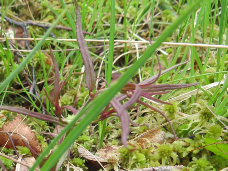
Cow-wheat (the purply thing at the back. No flowers yet.)

Lousewort

White lousewort!
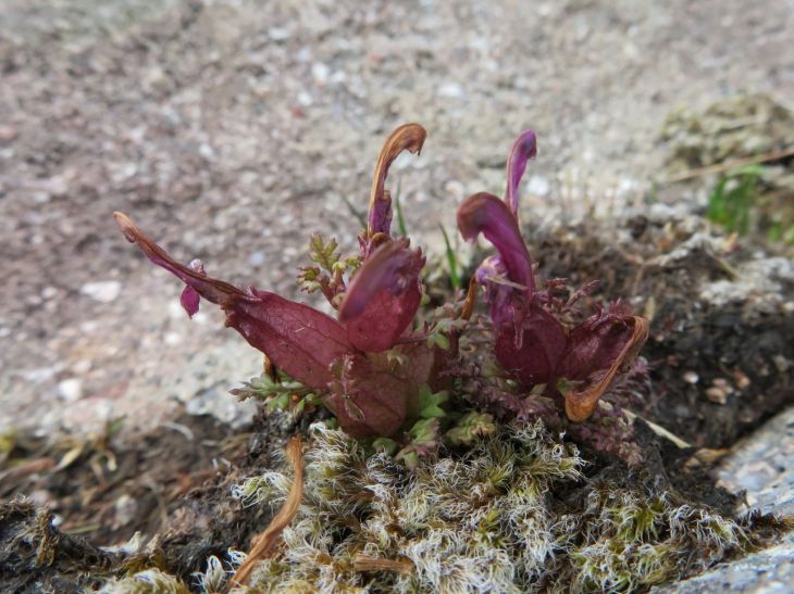
Normal lousewort but looking odd.

Oblong leafed sundew

Cuckoo flower (not something more exotic like we thought)

Veronica speedwell

Milkwort (unfortunately not all in focus – still getting used to new camera)

Milkwort (and two dogs)

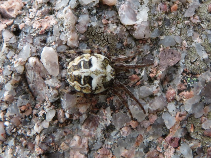
An orb weaver

Same orb weaver – hard to photograph – very fast!
A different orb weaver (and some lovely sandstone)

The second orb weaver again.

A beautiful, big drinker moth caterpillar

Same one – Euthrix potatoria

The other end, plus some lovely Hylocombium splendens

Probably a violet ground beetle

Black throated diver

The other of the pair of divers. We also saw a pair of pintail later – identified by the sound they made and general look in the air since they went past so fast and far away.

An egg shell found on the way back – probably a Dunnock?? (pale blue)

Some nice scenery from the walk

Looking back the way we’d come.

Suilven and Canisp

Happy dog!
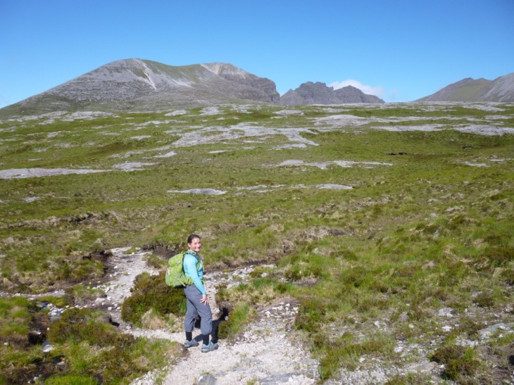
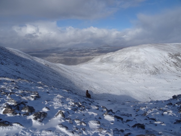
An Teallach
This post is written for a couple of people in particular, so excuse it for not being a full “walk report”, but rather an assessment of how difficult I think An Teallach is.
For those who don’t know, An Teallach (the anvil) is a mountain about 8 miles (as the crow flies) south of Ullapool, consisting of several peaks and a section of very rough, pinnacle-y ridge. It is this ridge that makes An Teallach famous as it is considered one of the most difficult ridge walk scrambles in the UK. It is technically classed as a scramble, although a lot of people recommend ropes for some parts of it.

I’m not that into climbing. I like it, and have done a bit, but don’t know enough about it to just go out and do it, and it takes a lot more organisation and equipment than I usually want to deal with. Scrambling however,… scrambling is perfect. It’s like going for a normal walk, and then climbing up some stuff while you’re out there. I haven’t done much “formal scrambling”, on recognised routes, or where that was the intention. I have, however, done a lot of “accidental scrambling” where I’ve picked a route up a hill (usually taking a shortcut) and then realised it is a whole lot steeper than I thought! The small amount of rock climbing that I have done also helps my scrambling ability.
So, An Teallach. I had got it into my head to do this hill… and not just the peaks, but the entire airy ridge walk. You can just do the peaks, in two goes, from either end. Or you can do all the peaks and a traverse, by taking the bypass trail, which is a fairly level trail just down from the main ridge. However, from what I saw of it, it looked very loose and scree-y and generally not like a fun walk. I would certainly never go out intending to take this path, although it is good to have it as a backup option if you can’t get across the top of the ridge for some reason.
I have a mad-keen scrambling friend (let’s call her Kirsten) who did the An Teallach ridge years ago and was keen to do it again. And happy to nurse me through getting into proper scrambling with the help of her vast experience, enthusiasm and extreme confidence. Luckily she’s also practical and realistic so I could trust her opinion of what I could and couldn’t do. Going out with someone who massively overestimates your ability is almost as bad (or maybe worse) than going out with someone who knows nothing.
We had two practice days before An Teallach. The first day we went on a gentle stroll along the Postie Path (Strathcanaird to Achiltibuie), then ended up climbing up the nose of Ben Mor Coigach. In incredibly strong winds. The second day we went up Stac Pollaidh, reaching the actual summit and climbing everything we could find on the way (and afterwards). Also in incredibly strong winds, and at 8pm at night (which was great, because it meant that even though it was June, we were the only people up there). These days not only built my confidence (or, more accurately, got my head into climbing mode and silenced that tiny voice that instantly says “ooo, this is scarey, you might fall and die, you shouldn’t do this”) but they also gave Kirsten a chance to assess my scrambling ability.
(You may get walk reports about these other days, and the day after An Teallach when we “accidentally” went up Suilven, but I can’t be sure yet)
We started at the carpark near Corrie Hallie and walked in along the track south of An Teallach, then up the flank to Sàil Liath. This is a fairly straightforward long slog, although there are some nice airy bits just before the summit. The purpose of today’s walk was to make the most of the exposure, views and rock, so we did walk along the edge and look off everything we could even at this point. I think this served a second purpose (the first being fun) of desensitizing us to heights and getting our eye in.


Coming off the first summit and heading towards the ridge, we knew we would be coming up to “the crux”: the most difficult part of the scramble. This happens at the very start of the pinnacle ridge walk. Kirsten remembered encountering a big, sheer, impassable wall on her last time here, which she ended up trying to climb around and almost falling to her death (that may be slightly melodramatic, but you get the point). We’d also already met a hill walker coming down who said he’d come across an impassable wall so had turned back and was calling it a day. We were on the lookout for this super scary, incredibly difficult bit of scramble that would soon appear in our way, potentially stopping us from achieving our goal of standing on top of all the pinnacles.
In the meantime, we enjoyed the “easy” stuff, climbing up anything that looked like fun and looking off the edge a lot. The rock was really lovely – nicely weathered sandstone. Very intact, so not flaking off. Lots of joints and bedding planes that you could get fingers and toes into, rough, rounded edges that you could hug up against and that you could get a good grip on.
Eventually, after lots of playing around and having fun, we concluded that we were actually already on top of the first pinnacle (there are four main ones) so we must’ve been past the crux. And I don’t mean bypassed…. I just mean that we’d done it and not realised it was the crux. There was no impassable wall, and no terrifying moments. We discussed it at great length, and googled it a lot when we came home, and did work out where the crux was. And it was the hardest point of the whole walk. But it was definitely not an impassable wall.
I will try to tell you about it.
We came across a section that was a bit more solid (and therefore harder to climb) than most of the hill. You could continue on at the base of this rock, but it did not present any better opportunities to get up it. I tried along this way for a bit, and ended up at a smooth, slick face which I had a go at getting up, but was really not happy with it. Meanwhile, Kirsten had gone around the face of the rock towards the steep side (northern) of the hill. She had found a way up there, so came back and got me. “The way” involved climbing up about 4 metres in a roughly 30o cleft in the rock. This required some climbing skill, but the real difficulty came from the fact that this cleft was very close to the sheer cliff into the corrie. Maybe a couple of metres away, albeit with nice flat solid stone under foot. The climbing itself was not particularly difficult. Not exactly beginner climbing – I definitely needed fingers and toes and some understanding of how to best use my weight while climbing – but not expert climbing either – as I said, I haven’t done much climbing, and certainly no formal climbing training and don’t know any technical things. One thing I remember, which may help you get a better feel for both the risk and my climbing ability was that at one point I thought (as I was climbing facing the southern wall, with my back to the drop into the corrie) “hmmm, if I fall off this now I’m going to go straight backwards and off the edge. Maybe I should turn around.” So I turned to climb facing the north-western edge of the cleft, so that my force off the wall, and my weight, would push me back towards the south, the shallow slope and the body off the mountain, rather than straight off the edge. I felt much more comfortable then and climbed it without any problems.

I believe somewhere in this is the crux. maybe about half way up the darker rock section on the left.

I believe this is the view along the exposed wall to the side of the crux (probably where Kirstin had her earlier near-death experience)

This is the tiny bit of ground between the crux and the corrie.

Me, on the way up. Still facing the wrong way at this point.

Now half way up, turned around a bit.
So, that is the crux. It does take a little bit of climbing ability, but also requires you not to freak out about the VERY large sheer drop just to one side. A lot of people take a rope, just to give that sense of security (and, OK, a safety net) on this bit. Alternatively, if you are not comfortable going up it, you can bypass the first pinnacle (on a boring, screey path just below the rocky summit) and come up, I think, between the first and second pinnacles. At this point you could backtrack onto the first pinnacle if you really wanted to see what was up there.


After the crux (having not realised we’d done it), we took the highest route we could take, over the very top of all the pinnacles. We climbed up and down walls that were pretty vertical, but had so many good hand and foot holds that it was like a children’s playground. They also all had solid ground at the bottom, so we were never hanging over an abyss. We walked up rocky steps that were a little exposed and I didn’t like the look of, but that Kirsten told me was a Grade 1 scramble “which means you can do it without hands”. So I did! (scrambing has three grades, 1, 2 and 3 in order of increasing difficulty) In general, we just had loads of fun climbing up anything we could, finding routes over and around things and enjoying the sense of space and air.


We also had a mission to find “Lord Berkeley’s Seat” – a famous vantage point that we had been led to believe (or led ourselves to believe?) was incredibly exposed. Since we didn’t actually know what it looked like, we just took a photo of Kirsten on every single terrifying, exposed, overhanging piece of rock that we could find. Except one, which even she wasn’t crazy enough to go out onto. Note here that Kirsten went out onto all the crazy “seats”. I stood well back off the edge and took photos. And occasionally asked her to go closer to the edge so I could get a better photo. I like being up high, and looking off sheer cliffs, but I do not trust my balance enough to go and stand on the edges of things. An Teallach does not require you to do that. There were plenty of sections where Kirsten walked along a line of blocks right on the edge of a sheer cliff. I walked half a metre away, on the next line of blocks so I could see straight off the edge but was not at risk of one tiny moment of inattention throwing me screaming into the abyss. It’s like I was walking on the steps and she was walking on the handrail…..
Enough about that. Back to Lord Berkeley’s Seat. We also googled that, a LOT, when we got home and we finally concluded that it was a fairly uninspiring piece of rock that was nowhere near as death defying, or as good a view, as most of the ones Kirsten had been on.


It was quite sad when we got to the end of the pinnacles, but we duly finished off with the second Munro of the walk, and then a bit of scree-ridge, and some more rocks that didn’t really need climbing but we did anyway (including fake-hanging off the edge, taking photos to make it look like we were hanging in mid air, but were actually about a foot above the ground), before descending a very steep grassy slope into a lovely corrie (Glas Tholl), then onto a stalker’s path, and back to the road. Except that we got lost in a massive rhododendron forest just before the road, to the point that we could hear the road only metres away but we couldn’t get to it!! Clearly we got out eventually but that was definitely the worst point of the whole walk.


We set off just after 8:30 and finished at around 7pm. It took 10 ¾ hours for us to do about 20.5km and 1600m vertical ascent. It was a long day but only because we took so much time playing around on top. I would love to have been able to get to the rest of the peaks and ridges, but for this trip, our time was much better spent enjoying the pinnacles. The weather was perfect: full sunshine, warm but not too hot, dry, and a very light breeze. We picked the best day to do An Teallach. This is not a walk I would want to do in either high winds or wet, slippery conditions. Damp would be OK, but not really wet…. and why would you when you’re doing it for fun? I would definitely not do it in winter. Climbing would be much more difficult with frozen fingers (or gloves), and I don’t like ice (or snow) when I’m that exposed. Interestingly, one of the easiest way of finding “the” route was to look for scratches on the rock from people doing it in winter with crampons on. Presumably they have ropes and/or MUCH more experience than me!!
A summary? This was a fantastic walk, and is quite doable if you have any aptitude for scrambling/climbing. I would only do it in good weather though. Also, if your head is not in the right place, it might be worth putting off for another time, or building up some more confidence on other hills. The scrambling we did on Ben Mor Coigach and Stac Pollaidh was much scarier (in places) than what we did on An Teallach. I don’t know how much it helped me to have someone much more experienced than me at scrambing and routefinding. I’m pretty sure I could still do it by myself, although it wouldn’t have been as much fun.

A Christmas walk
NOTE: apologies for the slightly dry nature of this post. I mainly wrote it to update my Walk Log for my Mountain Leader qualification, so it is mainly about all the sensible decisions I made and how much I thought about things that would make me a good Mountain Leader. Just thought I would share it with you all while I was here. I’ve been planning to do my Mountain Leader qualification for a while but was initially stumped by the need for 20 “Quality Mountain Days” before even doing the training course (over 6 hours and up a substantial hill – I’ve done lots of >6hrs, and lots of “up a substantial hill” but these things often do not happen on the same day!) and am now stumped by lack of time! I do have a few more walks I’ve done that I hope to put up here, but let’s wait and see if I can do that before I make loads of promises! I am still alive, am still in Scotland and do still get out occasionally (but not that often). Also, meet Loki: 8 month old Belgian Shepherd from the Czech Republic who is going to be my sheep dog.
Wanting to get away from all the human relations issues of Christmas, and feeling slightly better (and stir crazy) from a nasty cold, I was determined to go up a hill for Christmas. Beinn Dearg is one that has eluded me on one attempt already, but didn’t seem quite right, so I settled on the two-Munro circuit of Meall nan Ceapraichean and Eididh nan Clach Geala instead. It met the needs of a long easy walk in, safe and free from deer for the dogs, and a bit of time at height with a variety of summits to save it just being a peak-bagging slog (dash up and dash down). A circumnavigation of Glas Bheinn was the backup in case of bad weather forecast for Beinn Dearg.
Unfortunately I woke up Tuesday morning feeling pretty awful. The cold was still in force, and staying up until 12:30am at a local Christmas Eve bonfire (including a few drinks) did not set me up for a good start. I had planned to leave the house at 8am, to get to the carpark by proper light, but ended up collapsing back in bed for another hour while deciding if I should call the entire walk off. After another hour to rest, I decided to crack on with the hill plan. Unfortunately, due to the bonfire, I hadn’t packed the night before, so still had to get all my hiking kit together (most importantly including headlamp, maps and compass).
We (Brendan, myself, and two dogs) set out from the carpark just after 10am, over 1.5 hours after I’d intended. Sunset was going to be at 15:35pm, so we had just over 6 hours of daylight. This would normally be fine, if we were all fit! However, I was still pretty weak from cold, Brendan was recovering from a sprained ankle, Merlin is now 7.5 years old (so I need to be a tiny bit careful not to push him too hard) and Loki is only 8 months old, so really shouldn’t be doing walks this long. However, he’s been out for several hours on flat walks before and I figured the rest of us would be so slow that he’d be fine (and he was).
We took it slow and steady. I knew that pushing any faster would just result in me not being able to go as far, and potentially not being able to get home again. It is a very good track, and a very gentle incline for most of the way. There is a sharp kick up before the bealach and, even before this section, I was getting quite tired and seriously doubting that I was going to make it even to the bealach, let alone to one summit, or the two I’d planned. We stopped for a bite of lunch (cheese and oatcakes) before the sharp kick up, rather than waiting for the bealach, which was an excellent decision as we were both sufficiently refuelled, by both the rest and the food, to reach the bealach in good cheer.
We had already been discussing alternative plans, and it was quite clear by the bealach that we were not going to make both summits and the off-path descent off the flank of Eididh nan Clach Geala. It was already 14:30 at this point, so 1 hour until sunset and 1.5 – 2 hours of light remaining. I was perfectly prepared to finish out walk in the dark, having brought a very good headlamp exactly for that purpose. However, I did want to be down below the steep section before dark. Not only was it steep, it was also icy from this section up, which would’ve made walking in poor light very difficult.
The summit of Meall nan Ceapraichean had looked to be a very long way away, but was only about 1km on the map, and looked to be reasonably easy walking. Guessing half an hour to the summit, half an hour back, and then another half to one hour to get down off the bealach left us enough time to safely do this before dark, so, on we pushed.
Beinn Dearg was also raised as an alternate option at this point but there was a lot more snow (and ice) up that way, and the route was much steeper and more exposed. None of us had crampons (unless you count the dogs’ claws), so we discounted it pretty quickly. Also, there is a long ridge past the Beinn Dearg summit and I’d like to have the time to walk out along the whole ridge rather than just dashing to the summit and back.
The walk up to the summit was a doddle. Very easy, very pleasant, with nice views (including 4 ptarmigan). The wind had picked up, so we stayed a bit lower down to be sheltered until reaching the summit proper. Then we struggled against what I would guess were 60+mph winds to take some photos at the summit before retreating back to the shelter again! Sadly I did not even look out at the lovely views of the Assynt hills, too busy looking the other directions and trying not to fall over! I will just have to make another trip up there, to finish the loop and appreciate the views. This was the only time of the day that the wind was a problem – a particularly gusty period happening to coincide with the short time we were exposed on the edge of the hill.
Getting down was also easy enough, and we saw two golden eagles as a bit of a bonus. We stopped for the second half of lunch which was another good decision – we were going to miss it and keep walking to save time and make the most of daylight, but in the end I think it’s almost always more beneficial to eat when you need to than try to push through hungry to save time, especially if you are already under the weather. We were off the steep part before the light had faded much and managed to get all the way back to the forestry track before it had faded completely, so we didn’t need to get our headlamps out. Once on the forestry track it was pretty dark but it is such a good track, and light coloured, so we still didn’t need headlamps. I’d much prefer to avoid artificial light when walking if possible as it limits your peripheral vision so much and narrows your world to just where your light is pointing.
We got back to the car, all pretty exhausted but generally OK, by about 5pm. The car park was empty when we left and empty when we returned. A good day on the hill! My GPS tracker says 21.5km and 6.5 hours, but I managed to accidentally pause it coming down from the summit, so I would guess closer to 23km, and 7 hours.


Another bird survey…..
I did another round of bird surveys recently. I’d be much more efficient at them if I didn’t stop to take photos all the time! Still, then I wouldn’t get to share these lovely pictures with you.
Anyway, I didn’t see as much as last time, or even hear as much. I did see meadow pipits (of course!), dippers (a new one), sandpipers (lots) and stonechats, and also heard a ring ouzel and a couple of snipe. Here are two days worth of pictures……


As a hiking, and general wellbeing, note, on the first day I did 25km (almost entirely cross country) and 1,500m vertical ascent. I fell in one hole (up to my knee on one foot), and also dropped my heel into another hole (hyperextending my knee). I was physically fine the next day, but mentally shattered and thereby fairly useless in the Tearooms after 1pm. The second day I did 18km and thoroughly enjoyed it. My fitness is obviously coming along well as it felt easy, even with 900m vertical ascent, much of it up significant slopes (rather than slowly edging up the side of hills). I managed to drop the same heel in another hole, hyperextending the knee again, but it was still fine the next day. The back of that knee has been hurting a bit anyway, so I figure it serves it right. Maybe now it’ll behave again.

New jobs
It has definitely been too long since I’ve written anything. Most of you will know that the main reason for this is that I have a new job – owning and running (in partnership with my mum) a small cafe in a tiny village in the north west Highlands of Scotland. As well as being an engineer (or “modelling consultant”), I’m now a professional cake baker, barista, cafe worker and administrator. I’m also hoping to get out hiking enough to get my Mountain Leader qualification so I can be a professional mountain/hiking guide.
But this post is not about any of those jobs. This is about my latest professional detour. I’m now a professional ornithologist! I’ve just spent 2 days conducting a moorland bird survey. This is actually the second time I’ve done it this year, but the last time someone else did half (or more) of the work. This time I had to do the whole thing on my own. So,….. 2 days, 43km walked, 350 miles driven and a blissful 22 hours of not having anybody else near me! (much needed now that I share a house and work in a cafe every day)
I saw (or heard) a wonderful range of birds including meadow pipit, skylark, stonechat, ring ouzel, wren, redpoll, sandpiper, greenshank, golden plover, buzzard, cuckoo, snipe and possibly a golden eagle (it was too high for me to identify properly) and less possibly a merlin (too far away). The big red dog Merlin was not able to come due to ground-nesting birds. I think I would’ve seen some grouse and more snipe if he’d been with me.
I also saw some lovely flowers (I haven’t been out much this year so have been missing the procession of things flowering), butterflies, moths, a caterpillar, spiders, trees and rocks. I also saw loads of red deer, including one young calf, one Cheviot sheep and lamb and a few (luckily friendly) cows. I don’t know my cattle breeds very well, sorry!
Here are some pictures for you, to hopefully appreciate (and maybe be jealous of) my “office” for two days.


Emergency Locator Beacon
I know I have had some of you worried a few times on some of my crazier solo hikes, so I’m happy to announce that I now have a Personal Locator Beacon (PLB) for emergency situations. I have been considering getting something like this for a while, but have just not got organised and not felt too much urgency. Some of my hikes recently have been a little more risky and it seems that the older I get, the more conscious I am of every tiny little thing that could go wrong. My primary goal of every walk is to not have to call a helicopter so I’m usually very careful not to go beyond my limits, where I might end up stuck, lost or cold. However, there is always a chance that I can slip and do a fairly minor injury such as a broken ankle or leg (yes, I’m counting that as minor). While I’m happy to try to drag myself off a mountain or across several kilometres of bog in that state, if the weather is poor (ie cold), crawling/dragging myself may not be enough to maintain my body temperature. Obviously there’s also a smaller chance of a more serious injury which I can’t even crawl through, so the helicopter option is a good backup to have!
I have purchased a Ocean Signal “rescueME PLB1”, recommended to me by a hiking friend from Australia. The device is designed for marine use, but works effectively on land too. The box tells me quite emphatically that this is not an EPIRB, but the best description is that it is very similar to one (there is quite a good explanation about these things here). The rescueME works with a worldwide dedicated search and rescue satellite network (apparently the only officially recognised one, operated by Cospas Sarsat). When activated, it alerts the nearest Rescue Coordination Centre of my coordinates (hopefully to within 100m). This accuracy is pretty good, but then there is also a homing beacon so that once the search party is within 100m they can find me straight away.


The device is waterproof to 15m, has a 7 year battery life and, I’m delighted to read, is the smallest PLB available. It is only 75mm x 51mm x 31.5mm, and weighs 116g. The PLB itself does not float. However, it is supplied with a pouch that will float with the PLB inside. This makes it slightly bigger and heavier, but does make it float, and allows you to attach it to a belt or strap. If you don’t want to do this, it does have an alternative belt/strap attachment piece. I think I’ll just leave it in the floating case, just in case!


The device has a retractable metal antenna and a flap which covers the activation button so you can’t accidentally turn it on. This makes me a lot more happier!


The homing beacon will operate for over 24 hours once activated, so they have a full day to find me once I’ve activated it before they have to resort to mindless brute-force searching.
I have now registered the device with the UK Coastguard (a form was supplied in the box, but this was very easy to do online at https://forms.dft.gov.uk/mca-sar-epirb/). I assume other countries have a similarly easy registration method. It is compulsory to register EPIRBs/PLBs with your local rescue organisation, but just because I have registered my device with the UK Coastguard, doesn’t mean I can’t use it abroad. At least that is my understanding!
I have also tested my device, both the emergency beacon and the GPS. The instructions for these are quite specific. The beacon has to be tested in the first 5 minutes of an hour because it sends a short burst on the aircraft distress frequency, . . . and obviously they are told to expect short bursts for testing equipment in the first five minutes of each hour??? Other than that, testing the beacon is quite simple. Simply hold the test button for 1 second and note the colour of the LED flash. The colour and number of flashes indicate how long the battery has been used for and/or the type of failure. Thankfully, mine passed with “0-1 hours of battery use”. They recommend testing the beacon once a month. I will try to stick to this. After all, there’s no point going to all the trouble of getting one and taking it walking if I don’t even know it’s working properly! If I’m not out walking for over a month though I won’t bother testing it until just before the next time I take it out.
Testing the GPS takes slightly longer, but still virtually no time at all. You have to press and hold the test button for 10 seconds. After that, the LEDs will flash a certain sequence until it has a GPS fix. It will then flash to tell you the number of remaining times you can test the GPS. This test takes a fair bit of battery power, so you can only test the GPS a certain number of times before it will start to impact on the guaranteed 24 hours of emergency beacon operation. They specify a maximum of 10 GPS tests over the life of the device and recommend testing this function once per year. Again, happy to report that my device passed with flying colours.
(You have to have the antenna extended for both tests)
You have to replace the battery any time you activate the device, even for a short time. Note, this means “activated”, not “tested”. The battery is replaceable, but you have to send it back to an authorised dealer to have this done. Honestly, if I’ve activated it and it’s saved my life, I’ll be more than happy to send it back to the dealer to replace the battery!! You can also replace the battery after the expiry date. I feel like technology will have changed so much in the next 7 years, that this is unlikely to be necessary – a new, smaller, cheaper, faster alert device will certainly be available!
My rescueME PLB1 cost me £199 (RRP £282), delivered to my house from a shop in Inverness. This is quite expensive, but there are no ongoing subscription fees and it should last for 7 years. Plus, I had enough people telling me they’d buy one for me if I didn’t get one for myself!! It is a lot to pay for a device you hope to never use, but a small price to pay for peace of mind and potentially your life.
The locator device which seems most well known is the SPOT tracker (technically “SPOT Gen3 Satellite GPS Tracker/Messenger”). This device is a similar size and weight to the rescueME PLB1 but has replaceable AAA batteries (they last between 3.5 and 52 days if turned on and tracking, dependent on tracking frequency and sky visibility, or for at least 6 days in SOS mode) and the emergency location works through a different system (I think it works through the SPOT satellites whose system then contacts the GEOS International Emergency Response Coordination Center?). The SPOT has a load of extra features, including being able to send pre-programmed messages to friends or family (eg saying “All OK” or “All OK but running late” or “Help please. Come pick me up”) and having an online live tracking system so family and friends can follow your adventures. The initial cost of the SPOT is less (~£120 – £160), but there is a mandatory annual subscription fee of £130/year.
Based on this, my rescueMe PLB is a fair bit cheaper already! I also only want an emergency device. I’m not interested in the hassle of checking that my SPOT batteries are charged, programming in messages to friends, and setting up my online tracking all the time. I also don’t have any specific adventures that I want all my friends/family/general public to be able to live track me on and, frankly, am not interested in paying £165/year just so you can see where I am. Sorry about that guys!
Because I’m an engineer, here is a table with some comparison stats:
| Device | rescueMe PLB1 | Spot Gen3 |
| Size (mm) | 71 x 51 x 31 | 87 x 65 x 25 |
| Weight (g) | 116 | 114 |
| Battery Life (days) | 2,555 | 52* |
| Purchase Price (£) | 200 | 130 |
| Annual Subscription (£/yr) | 0 | 130 |
| Price over 7 years (£) | 200 | 1,040 |
*This is SPOT battery life while tracking at a certain frequency, in 50% clear skies. Sorry, I can’t re-find the very detailed SPOT FAQs on battery life that I used to calculate this. SPOT Gen3 battery life is 2 years on standby, and 156 days tracking every 60 minutes (probably in 100% sky exposure?).
That’s the end of this review. All good so far and hopefully I never have the opportunity to report on the efficiency of the rescueMe PRB1 in operation!
On a slightly different scale of cost and importance, I’ve also just received my new watch for hiking (since the band broke on the old one). It’s a Casio W-59-1VQES and cost me a whole £7.95 including postage! Pretty exciting! So far it is small, lightweight and easy to use. Now let’s hope it lasts!
Actually, I’ve just found another really interesting link, and review site, here.
Spring is springing! (March)
This should really have been posted in March, but since I have a little time now and still really want to talk about this stuff, I’ll post it now. Hopefully there’ll be a couple more coming, about the progression of spring here. So, for now, pretend it is still March and enjoy the first feelings of spring in the NW Highlands!
I went back to Australia in late February for a three week holiday. When I left Scotland it was very much winter.

Driving down the A9 on the way to Glasgow Airport.
When I returned, suddenly it was spring. I felt like I’d missed the change. The weather was warmer and felt more stable. Daffodils were blooming. Birds were singing. And new plants were starting to sprout.
I loved the winter here, but realised how static everything had become. Hardly any birds and a relatively small range of plants (and them not changing much).
My first few walks were an absolute treasure trove of finds. The first thing to catch my eye was Hare’s Tail Bog Cotton (Eriophorum vaginatum), which I’d not seen before and took quite a lot of effort to identify (mainly because I was describing it over email from memory!). When I took the camera back out to re-find my Bog Cotton (or Cottongrass, as it seeems to be properly called), I also found an Emperor Moth cocoon (Saturnia pavonia). Still haven’t seen one of the moths yet, but they are very beautiful (see here).


This was all on the fairly standard boggy ground. The next day I headed up to the hill where the rocky cliffs provide both shelter and richer soil. The primroses were already flowering, and lots of the other early flowering plants were poking their leaves out for the first time.


There were also some lovely young ferns, some bright new clubmoss and even a bog thistle (I think).


I’ve been learning a lot more about my mosses and lichens recently, partly as they were one of the few things left in the winter, but also because there is some new growth at the moment which is quite striking and interesting.


A few days later and all of the trees were budding. I’ll need to do some more work next year to be able to identify these by bud. At least I could recognise a willow! (I think . . . now I’m doubting myself!) I also saw my first frog of the season, plus what looks like some half developed tadpoles (probably killed by a recent frost).


Stay tuned for the next installment (from April) of the progression of spring!
A wintery April afternoon on Glas Bheinn
After a very annoying week of work I was desperate to get out on a hill. I’ve been admiring Glas Bheinn (the hill next to Quinag) for a few weeks now and was heading down that way, so decided to go up it. Due to my frustration and anger with work there was very little regard for the weather – I was going no matter what. I had checked the forecast, and solid rain may’ve put me off. As it was, it was just for snow and wind so we went. I think, in hindsight, I hadn’t really thought this through and it was not surprising that I didn’t see a single other person out on the hills or in the carparks that day.
There is a track along the western side of Glas Bheinn. You may remember it. I tried to walk along it two years ago from the southern end and it quickly became a typical Scottish track (ie. NOT a track!). However, other people have mentioned walking along it (at which I gaped in surprise), and the northern end does stand out significantly against the hillside. I wanted to give it a try, so I parked where the northern end of the track meets the road and set off along it.
It is actually a very distinctive (if still quite boggy) track at the northern end. I walked along it for quite a while and it was still very much a track, so there must only be a small section in the middle that is terrible . . . or I lost it at some point and was wallowing around a few metres from a perfectly good track! The snow started falling at some point along the track and gradually intensified, soon lulling me into that beautiful, soothing solitude that comes with walking along in soft falling snow. The wind was at my back so it was peaceful in the cone of silence that was my rain jacket hood.

Setting out, with a great path, some sunshine and just a hint of snow on the hill

Falling snow. Still a novelty for me. (A track like this is also a bit of a novelty)
I startled a herd of deer and they, sensibly, ran off down to lower ground. I turned the other way and headed up the hill. The plan was to skirt the southern edge of the hill, pick up a track that runs along the eastern side, drops off a hanging valley and meets up with the track to the Eas a’ Chual Aluinn waterfall. (Sorry, I thought I’d told you about my walk last June to the waterfall, but can’t find it in a blog post, so I guess I haven’t!) I was then going to follow the waterfall track back west and cut back up onto the hill from that edge, following around the top of the main corrie that faces north.
The snow was becoming somewhat blizzardy at this point. Luckily I was on the lee side of the hill, so it wasn’t too bad and the wind was still mainly at my back. Visibility was a hundred metres or so, and certainly nothing off the hill to get my bearings from. Still, I knew I was just skirting the hill so as long as I stayed at about that elevation I’d be alright.

Heading across the hill . . . starting to get a bit more serious.

Yeah . . not sure where we’re going now.
A bit further on and there was a very steep downwards slope in front of me, and some evidence of cliffs. This wasn’t part of the plan. I had the compass out and had been walking roughly the right direction. Still, not being able to tell exactly where I was, it didn’t seem advisable to attempt a slope when I had no idea how steep it was going to get, nor how far it would be to find the track at the bottom. Did I mention that I didn’t start this walk until 3:30pm so I didn’t have unlimited time to wander around? And it was 2 degrees at the carpark, so was probably about -2, plus windchill up here?

Merlin has finally learnt to eat snow when there is not water around (or the water is too cold to drink)
I made a very sensible navigational decision . . . which probably sounds a bit stupid! Rather than heading downhill for the lowland track, I decided to go uphill (in the snow and 40mph winds). At least this way I would know where I was when I got to the top of the hill and could navigate home from there. I also knew this would be a much shorter route than the original plan which could’ve ended up being hours longer if there were any (more) navigational problems.
I headed upwards and the weather got worse. I was now walking into the wind and my face was starting to hurt from the cold – no, I hadn’t thought to bring a buff or scarf. I also hadn’t thought to bring walking poles, which I was regretting. The snow was thick enough to hide all of the rocks, but not thick enough to stop me from falling down the gaps between the rocks. Glas Bheinn, being a blocky quartzite hill, had LOTS of rocks, with lots of gaps perfect for trapping ankles in. With the weather deteriorating, very little visibility and difficult walking conditions I was starting to get worried. Was I in over my head? Had I misjudged the conditions and underestimated the hill? Was I putting myself into a dangerous situation? I was also losing confidence in my navigation, with my compass continuing to defy all of my estimates on direction (based on landscape shape, not on pure sense of direction as I already know that is useless!).
I stuck it out for a bit longer, with a bit of positive self-talk and a bit of stubborn determination and recklessness.
Then the wind stopped and the sun came out. The change was incredible. Not only could I see directly in front of me without squinting, but I could see all of the surrounding hills so I could tell exactly which direction I was going. I could take my hood off and warm my frozen cheeks in the sun. I could walk in a straight line without being blown sideways. I could see the sun sparkling off the pristine snow. I could watch the tiny snowballs rolling hundreds of metres down the hill, slowly gathering speed and size, from where Merlin dislodged them somewhere up ahead. It was glorious. The snow was untouched (except for the giant dog prints). Every now and then a flurry of snow would dance across the top of the ridge. There was not a single other person for miles. The view stretched before me . . rows of snow covered hills in one direction, and sparkling lochs stretching to the sea in the other.

This would’ve been a lovely photo except that Merlin got sand in my camera 9 months ago so the lens cover still doesn’t open properly. Pretend it’s a “as if you were there” photo and that is a rainjacket hood.

Lots of lovely dog shots today. Love his crusty eyebrows.
The track I was going to meet up with goes through this valley and drops off the edge between the two hills. You can also see part of the Moine Thrust through here (the nobby Stac of Glencoul that is at the end of the loch in most of my work photos)

Much easier to tell where you are (and going) when you can see things!
We walked along the ridge like this for a while before the weather closed in again. Luckily I soon spotted the summit cairn, standing out dimly against the grey shrouded sky. It is a lovely cairn, with a sizeable shelter next to it too. A lot of the rocks used to build it are red, so Merlin looked quite at home there. He posed beautifully between the two for me, then joined me for a romantic selfie.

Summit cairn . . .

Quite a large summit cairn!
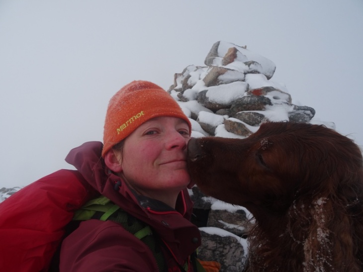
Awwww . . kisses. How sweet.
With visibility down to almost nothing again, it was back to navigating with a compass. I took a bearing from the map that would lead me along the north-western rim of the corrie, from where I could drop down the gentlest part of the slope to where I had started. Within a short time I came to a very steep slope. I should not have encountered that. On checking my map and compass again, there was no way that what I was seeing in front of me could possibly be in that direction. Was my navigation really that bad?? I had a decision to make . . . go left or right. I eventually chose right, based on some logic and landscape clues, and in complete defiance of what my compass was telling me.
It was the correct decision and I was soon back where I needed to be, and overlooking the main northern corrie. The cloud cleared enough to give me a view of the loch at the bottom although the wind was pretty savage at this point so I almost; dropped the camera; got blown over; and got hyperthermia trying to take this photo for you (so no complaints about the snow drops all over the screen!).

Looking north. It was not easy to get this photo for you!

Slightly down out of the wind and looking east (we are not going down that way!).
After taking that photo I snuck down below the ridgeline again and started a slow, angled descent along the spur. It was a very slow descent, with much more sideways progress than downwards progress. Eventually the way ahead looked like it was getting steeper so I turned and headed straight down the side. It was very steep. Some parts were all scree. High up, the footing was difficult because of the snow obscuring the rocks. Lower down, the scree simply slid underfoot like a mini landslide. Luckily there were large strips of moss and heather which provided much more secure footing . . . although still very steep and difficult!
My knees were not liking me at this point. I was also acutely aware of the risk of slipping or toppling and rolling all the way down to the bottom of the hill. The chance of serious injury from not paying attention was significant. This is one of those times I’m glad I walk by myself, as I continuously muttered to myself: “just keeping going down, nice and slowly, down, down, down, slowly down”.

Lovely view of the sun setting behind Quinag.

The way down . . . it’s quite steep. You can see the track at the bottom, and the main road. My car is there somewhere . . .where the track meets the road.
Once down, it was a very easy walk back along the track to the car. This is always a nice way to finish a walk and get some of the stiffness from descending out of my legs.
The total walk was about 9km long, with about 550m vertical height. It took just under 4 hours, although it didn’t feel like a long time. There were enough changes in weather, landscape, footing, emotions and planning to completely distract me from how long I’d been walking.
I took the opportunity to check my compass on the way back. The track I was on should’ve been due south of a sharp corner in the road ahead. I pointed my compass at the corner. The needle pointed off to the left somewhere. I was furious. It wasn’t my navigating that was terrible – it was my compass! It is pretty scary being in a situation with very little visibility AND a faulty compass. Almost, but not quite, enough for me to consider getting a GPS!
This was a fantastic walk, and I’m glad I got out and did a “proper” walk again. I haven’t pushed my limits much recently and I feel like this did. It’s nice to know I can still do it.
PS Every photo here has Merlin in it, except for two. Don’t worry if you can’t see him – now that I’ve reduced the resolution he’s not much more than a small black speck in some of them!


No complaints about winter in the NW Highlands
“What??? Another blog post so soon?” I hear you gasp. Yes, but don’t get used to it! Yesterday was an absolutely glorious day here and I took advantage of it, and have some stunning photographic evidence to prove it.
Glorious, to me, is sunshine, bright blue skies, snow on the hills, 2 degrees, a slight breeze and enough ice to be crunchy underfoot but not too slippery. Proper snow underfoot would’ve been even better, but I would’ve had to go a lot further afield to get that.
I didn’t feel like a hard walk, nor like going a long way to get one, so I decided to explore a little way up the Rhiconich River. The Cape Wrath trail recommends coming north along the north-eastern side of this river, despite warning that there is quite a deep wade, impossible in spate, across the Garbh Allt (rough river). I’ve always been curious about what this “deep wade” was like, and why they don’t suggest walking along the other side of the river, so I thought I’d have a look.
My walks quite often go like this:
1. First 20 minutes: enthusiasm, enjoyment and optimism
2. Next 30 – 40 minutes: really just wanting to go home
3. From here it either becomes a fairly determined drive to get where I’m going, or settles into a relaxed but steady rhythm.
Quite often it becomes a determined drive because I’ve been over-ambitious with my planning (or simply a little careless with my distance and terrain estimates, like one memorable occasion recently that I’ve told some of you about already!). It’s not that I want to walk really far and fast and work really hard. It’s just that quite often the places I want to go to are a long way away!! And I’m stubborn. And lazy in a crazy kind of way that means if I’m half way to somewhere, I’d rather push on and get there this time, than come back again another day over all the same ground.
Luckily today had no grand goals other than the Garbh Allt and the longest plan (walk to the end of the second loch, Loch a’ Garbh-bhaid Mor, and back up the other side) was easily achievable in the amount of time I wanted to be out walking. Well, it turns out I only just achieved it, . . . but that was with lots of stopping to look at things and generally taking it easy.
I even drove to the start of the walk! This is a big step for me, especially as this is only 2.5km from my house! Normally I would’ve just walked all the way from home. That would’ve turned this into another of those “fun in a really painful, exhausting way” walks.
Thanks to all of that, and a conscious effort to rein myself in and just enjoy the walk rather than having to go further or faster, this was a really enjoyable outing. After 2 hours I was thoroughly relaxed, at peace and incredibly happy. One of the nicest walks I’ve had in a long time.
Oh, and just so you know, the Garbh Allt was a knee high wade for me at normal water levels. I actually had to go upstream a bit so I could cross without getting water in my wellington boots. There is also no reason why you can’t walk up the south western side of the river and lochs so I have no idea why they recommend wading the Garbh Allt instead. The only difficult bit was right at the end near the Rhiconich Hotel where there is a section of forest on the south-west side. This was terrible to walk through. We need more deer to eat the trees down!! (in-joke: there is a big push from some organisations up here to cull more deer to allow more forests to grow back)
And now, on to the photos!
The photos are in chronological order so you can feel like you’re on the walk with me. (This started in slideshow format but I decided I didn’t like it so switched to tiled mosaic display. However, there was resounding positive feedback about the slideshow so I’m putting it back in. Just shows that my viewing habits and requirements are different to yours. Feel free to let me know what you think of slideshow format if you haven’t already. The first photo should be the moss, so wait for that one to come around if you want to watch them in order.)

12km, 4 hrs.
3 bothies, 2 trig points and 1 black toe
(Firstly, I’d like to apologise in advance for the number of photos. I think I need to set myself a photo limit, eg 15 per post, and stick to it rigidly. However, this is an area that I love, it was a stunning two days, and I’m being self indulgent as it is a birthday post. Please hover the mouse over photos to see the captions – I’ve taken the effort to put them in – you may as well read them and get more of the story)
Last year, the day before my birthday, I walked from Blairemore up to Cape Wrath, then spent the night in the bothy at Kearvaig bay. I woke, on the morning of my birthday, on a beautiful, remote beach, with deer at the window and a delightful day of walking ahead of me. I wanted to repeat that trip, exactly one year later.
It turns out I couldn’t, because they were bombing on the Cape the day I should’ve walked out!! Shortly after finding out about that I got called into work that day anyway, so it was kind of lucky. My friend who works at the range assured me that there would be no bombing for the next two days so I left on my birthday instead, technically an exact leap year after my first trip!
I left from home, at Oldshoremore, at about 9am. It helps having tried to leave the day before so I was already packed! It was a stunning day – bright blue skies, warm and a gentle breeze. A far cry from the grey drizzle that I had the previous trip.


We walked up the road to Blairemore, then followed the track to Sandwood Bay. From here we crossed the river (shoes off and shallow wade, then stop for a snack afterwards to dry my feet) …


…then headed inland to Strathchailleach bothy. This bothy is somewhat famous as one man actually made it his home (with no electricity, phone and the nearest road being almost 7km away cross-country) for many years. It is said, therefore, to feel a lot more homely than most other bothies. It even has a cat flap!!?! Strathchailleach means “valley of the old woman/hag”.


From here, it was across the Allt a Ghobhair (river of goats?) and up to the Cape. I’d seen a lot of people at Sandwood Bay, and a couple more on the way to the bothy, including one guy who was also walking up to the Cape. We walked together a little way, but went off at our own speeds after entering the military range. From here I meandered across the top of a few hills (Cnoc an Daimh and Cnoc a’ Ghiubhais) then up towards the Lighthouse before heading east to the trig point on top of Dunan Mor (big fort).


Then a meander east through peat hags and bogs to Kearvaig. I didn’t walk along the cliff edge since I had Merlin with me and, while he has been reasonably sensible with cliff edges so far, I don’t really like risking it on unneccessary and particularly “deadly” cliffs like these.
The bogs we had to navigate through.
As you can see in the pictures, it was a very sunny day. It was also quite warm. We had also walked quite a long way, up and down hills, over quite difficult terrain. Merlin was carrying his own dinner, plus coal for a fire that night. I was quite tired, with sore feet from constantly sliding into the front of my shoes on the hills. Merlin was hot and, it turned out, quite tired also. We were very happy when we finally spied Kearvaig at about 5pm. A bit of a wash in the Kearvaig River would’ve been delightful. Sadly the midges descended on us as we got into the sheltered valley near sunset!! So, a dash to the bothy, a dash back to the river to fill waterbottles, then we locked ourselves in the bothy for the evening (other than some sunset photos later on).


Merlin crashed out on the bench instantly, I lit the fire, heated water for my fancy birthday dinner and had a cider to celebrate. Some reading (a book I’d bought with me – what a luxury trip!) and some chocolate finished off a delightful evening before gratefully succumbing to sleep.


The next morning dawned just as brightly and beautifully. We set off early (6:30am) as we had a long way to go. We headed east to Sgribhis-bheinn – an entrancingly shaped hill with a gentle slope to the north and steep cliffs on the south west. Also, another trig point on top! Trig points are cool! They are always on high points (so you can see for miles), they are for surveying (and surveying is definitely cool), they were generally built here AGES ago (ages in Australian terms, not ages in UK terms) and they should be set up so you can always see 2 other trig points from one of them. So if you go to them all, you’ve sort of seen a network across the entire country. This was a proper, old-fashioned, trig point made out of stone rather than a solid concrete block. The view was also stunning, as to be expected.


We were then heading south west to Maovally, one of the larger hills on the Cape, and one I hadn’t visited yet. This whole area, between Kearvaig, Sgribhis-beinn and Maovally, is heavily used for bombing and military exercises. There a lots of signs warning of danger, explosive objects and potential death. We mucked around with an old sandbag fort, walked around a large bomb crater and even found a huge old shell!


Maovally has a lovely cairn, and some interesting sandstone pavement topography on top. Also stunning views, although it was getting a bit hazy so the photos aren’t great. It was still early, but with already 5km of walking and 500m of climbing today, plus yesterday, I was getting tired. Walking on the Cape is not easy. Not only are there no paths, but it is constantly up and down or, just as bad, walking sideways across a slope. The heather is thick, and where there is no heather it is usually thick, tussocky grass hiding soft marsh underneath. At this point I was torn between taking the shortest way out, or what looked like the lowest, easiest way out. I went for the easiest!!


We hit the fence around the military area in the perfect spot where it crossed the Kearvaig River so Merlin could get under the fence (this was planned). We then meandered up the river between Cnoc na Glaic Tarsuinn and Beinn Dearg (red hill). I would like to go up all of these hills one day, but was very much into survival and “just get home” mode! I had been planning on going up Creag Riabhach (the stripy rocks) to see another trig point but one look at the size of the hill scrapped that idea! It also would’ve meant a lot of extra distance as the northern edge is mainly cliffs so I’ve have to walk around to the south side, then walk up it.


Instead, I picked the shortest, lowest possible route home, via Strathan bothy. I skirted Loch a’ Phuill Buidhe (loch of the yellow pool or mud?) and crossed the saddle bewteen An Grianan and Meall Dearg (red hill). Again, two hills I’d like to go the top of one day . . but not today! As I got over the top of the saddle I realised that in my haste to get home quickly I hadn’t paid much attention to my map. The southern slope, at Sron a’ Ghobair (nose of the goats?) is VERY steep! 150m vertical in 100m horizontal . . . . I was actually not sure if I’d be able to get down for a while. At this steepness, you can’t see if the ground suddenly drops off a cliff below so at any point could end up having to backtrack and find another way. Luckily I did make it down, skirting to the east slightly and following the river (Allt na Rainich) down.


I was incredibly happy to finally see Strathan bothy. I have seen this one before, but only from the other side of the river so this is the first time I’ve visited it. It is a very nice bothy and I happily sat down for a while to read an MBA newsletter had been left there.


As I left I passed a young foreign couple. They really didn’t look equipped for proper walking so I’ve no idea what they were doing this far out. It looked like they must’ve walked up river from Sandwood Bay but it is still quite a long walk home with not a great track.
I left them to their own devices (they didn’t seem interested in talking), waded the river in front of the bothy (Abhainn an t-Srathain) and headed south west to intersect the vague path that goes from the main road to Strathan. I could’ve followed it directly from the bothy but it heads east before curling back and I didn’t want to walk the extra distance. Big mistake! As poor as the paths are out here, they are much easier (usually) than walking cross country. I probably walked for 1.5km before I found the path again across fairly flat, featureless bogs. Not that it wasn’t pretty . . . just that I was tired and really wanted to get home!
Once I found the path it was fairly straightforward, and I staggered home by about 4:30 (in time to get to the shop to buy food to cook dinner for a friend that night!).


Some side notes:
Yes, I had a black toe, probably incurred the first day. It is still, resolutely, black almost 5 months later!


I was exhausted when I got home. My tracker says that I did 50km over the two days, over hills and some very rough, boggy terrain, so that is not really surprising.

Red flags on the military range means “Danger. Active Exercises. No Entry”. As you can see in some of the photos, there are still some red flags out. However, I had been assured by staff that I was allowed in, and I did actually see the tourist bus when I was on my way up Maovally. Still, I felt naughty and nervous the whole time, and carefully avoided seeing anyone! That is why I didn’t go up to the lighthouse, left so early from Kearvaig and was generally keen to get out of the range on my way home!
