A wintery April afternoon on Glas Bheinn
After a very annoying week of work I was desperate to get out on a hill. I’ve been admiring Glas Bheinn (the hill next to Quinag) for a few weeks now and was heading down that way, so decided to go up it. Due to my frustration and anger with work there was very little regard for the weather – I was going no matter what. I had checked the forecast, and solid rain may’ve put me off. As it was, it was just for snow and wind so we went. I think, in hindsight, I hadn’t really thought this through and it was not surprising that I didn’t see a single other person out on the hills or in the carparks that day.
There is a track along the western side of Glas Bheinn. You may remember it. I tried to walk along it two years ago from the southern end and it quickly became a typical Scottish track (ie. NOT a track!). However, other people have mentioned walking along it (at which I gaped in surprise), and the northern end does stand out significantly against the hillside. I wanted to give it a try, so I parked where the northern end of the track meets the road and set off along it.
It is actually a very distinctive (if still quite boggy) track at the northern end. I walked along it for quite a while and it was still very much a track, so there must only be a small section in the middle that is terrible . . . or I lost it at some point and was wallowing around a few metres from a perfectly good track! The snow started falling at some point along the track and gradually intensified, soon lulling me into that beautiful, soothing solitude that comes with walking along in soft falling snow. The wind was at my back so it was peaceful in the cone of silence that was my rain jacket hood.

Setting out, with a great path, some sunshine and just a hint of snow on the hill

Falling snow. Still a novelty for me. (A track like this is also a bit of a novelty)
I startled a herd of deer and they, sensibly, ran off down to lower ground. I turned the other way and headed up the hill. The plan was to skirt the southern edge of the hill, pick up a track that runs along the eastern side, drops off a hanging valley and meets up with the track to the Eas a’ Chual Aluinn waterfall. (Sorry, I thought I’d told you about my walk last June to the waterfall, but can’t find it in a blog post, so I guess I haven’t!) I was then going to follow the waterfall track back west and cut back up onto the hill from that edge, following around the top of the main corrie that faces north.
The snow was becoming somewhat blizzardy at this point. Luckily I was on the lee side of the hill, so it wasn’t too bad and the wind was still mainly at my back. Visibility was a hundred metres or so, and certainly nothing off the hill to get my bearings from. Still, I knew I was just skirting the hill so as long as I stayed at about that elevation I’d be alright.

Heading across the hill . . . starting to get a bit more serious.

Yeah . . not sure where we’re going now.
A bit further on and there was a very steep downwards slope in front of me, and some evidence of cliffs. This wasn’t part of the plan. I had the compass out and had been walking roughly the right direction. Still, not being able to tell exactly where I was, it didn’t seem advisable to attempt a slope when I had no idea how steep it was going to get, nor how far it would be to find the track at the bottom. Did I mention that I didn’t start this walk until 3:30pm so I didn’t have unlimited time to wander around? And it was 2 degrees at the carpark, so was probably about -2, plus windchill up here?

Merlin has finally learnt to eat snow when there is not water around (or the water is too cold to drink)
I made a very sensible navigational decision . . . which probably sounds a bit stupid! Rather than heading downhill for the lowland track, I decided to go uphill (in the snow and 40mph winds). At least this way I would know where I was when I got to the top of the hill and could navigate home from there. I also knew this would be a much shorter route than the original plan which could’ve ended up being hours longer if there were any (more) navigational problems.
I headed upwards and the weather got worse. I was now walking into the wind and my face was starting to hurt from the cold – no, I hadn’t thought to bring a buff or scarf. I also hadn’t thought to bring walking poles, which I was regretting. The snow was thick enough to hide all of the rocks, but not thick enough to stop me from falling down the gaps between the rocks. Glas Bheinn, being a blocky quartzite hill, had LOTS of rocks, with lots of gaps perfect for trapping ankles in. With the weather deteriorating, very little visibility and difficult walking conditions I was starting to get worried. Was I in over my head? Had I misjudged the conditions and underestimated the hill? Was I putting myself into a dangerous situation? I was also losing confidence in my navigation, with my compass continuing to defy all of my estimates on direction (based on landscape shape, not on pure sense of direction as I already know that is useless!).
I stuck it out for a bit longer, with a bit of positive self-talk and a bit of stubborn determination and recklessness.
Then the wind stopped and the sun came out. The change was incredible. Not only could I see directly in front of me without squinting, but I could see all of the surrounding hills so I could tell exactly which direction I was going. I could take my hood off and warm my frozen cheeks in the sun. I could walk in a straight line without being blown sideways. I could see the sun sparkling off the pristine snow. I could watch the tiny snowballs rolling hundreds of metres down the hill, slowly gathering speed and size, from where Merlin dislodged them somewhere up ahead. It was glorious. The snow was untouched (except for the giant dog prints). Every now and then a flurry of snow would dance across the top of the ridge. There was not a single other person for miles. The view stretched before me . . rows of snow covered hills in one direction, and sparkling lochs stretching to the sea in the other.

This would’ve been a lovely photo except that Merlin got sand in my camera 9 months ago so the lens cover still doesn’t open properly. Pretend it’s a “as if you were there” photo and that is a rainjacket hood.

Lots of lovely dog shots today. Love his crusty eyebrows.
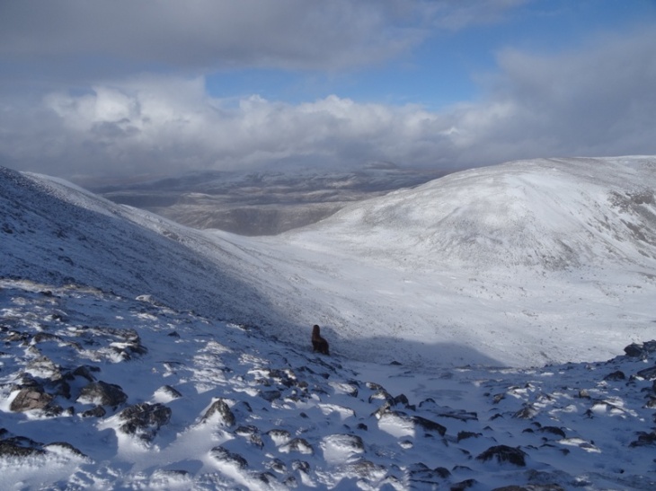
The track I was going to meet up with goes through this valley and drops off the edge between the two hills. You can also see part of the Moine Thrust through here (the nobby Stac of Glencoul that is at the end of the loch in most of my work photos)

Much easier to tell where you are (and going) when you can see things!
We walked along the ridge like this for a while before the weather closed in again. Luckily I soon spotted the summit cairn, standing out dimly against the grey shrouded sky. It is a lovely cairn, with a sizeable shelter next to it too. A lot of the rocks used to build it are red, so Merlin looked quite at home there. He posed beautifully between the two for me, then joined me for a romantic selfie.

Summit cairn . . .

Quite a large summit cairn!
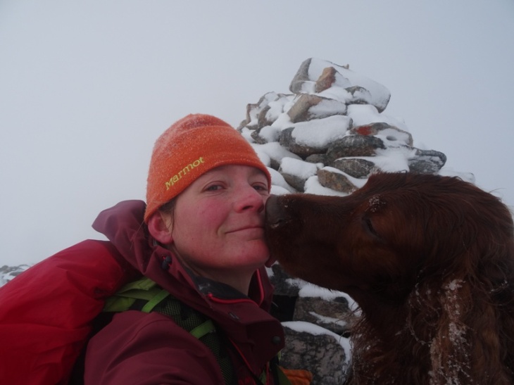
Awwww . . kisses. How sweet.
With visibility down to almost nothing again, it was back to navigating with a compass. I took a bearing from the map that would lead me along the north-western rim of the corrie, from where I could drop down the gentlest part of the slope to where I had started. Within a short time I came to a very steep slope. I should not have encountered that. On checking my map and compass again, there was no way that what I was seeing in front of me could possibly be in that direction. Was my navigation really that bad?? I had a decision to make . . . go left or right. I eventually chose right, based on some logic and landscape clues, and in complete defiance of what my compass was telling me.
It was the correct decision and I was soon back where I needed to be, and overlooking the main northern corrie. The cloud cleared enough to give me a view of the loch at the bottom although the wind was pretty savage at this point so I almost; dropped the camera; got blown over; and got hyperthermia trying to take this photo for you (so no complaints about the snow drops all over the screen!).

Looking north. It was not easy to get this photo for you!

Slightly down out of the wind and looking east (we are not going down that way!).
After taking that photo I snuck down below the ridgeline again and started a slow, angled descent along the spur. It was a very slow descent, with much more sideways progress than downwards progress. Eventually the way ahead looked like it was getting steeper so I turned and headed straight down the side. It was very steep. Some parts were all scree. High up, the footing was difficult because of the snow obscuring the rocks. Lower down, the scree simply slid underfoot like a mini landslide. Luckily there were large strips of moss and heather which provided much more secure footing . . . although still very steep and difficult!
My knees were not liking me at this point. I was also acutely aware of the risk of slipping or toppling and rolling all the way down to the bottom of the hill. The chance of serious injury from not paying attention was significant. This is one of those times I’m glad I walk by myself, as I continuously muttered to myself: “just keeping going down, nice and slowly, down, down, down, slowly down”.

Lovely view of the sun setting behind Quinag.

The way down . . . it’s quite steep. You can see the track at the bottom, and the main road. My car is there somewhere . . .where the track meets the road.
Once down, it was a very easy walk back along the track to the car. This is always a nice way to finish a walk and get some of the stiffness from descending out of my legs.
The total walk was about 9km long, with about 550m vertical height. It took just under 4 hours, although it didn’t feel like a long time. There were enough changes in weather, landscape, footing, emotions and planning to completely distract me from how long I’d been walking.
I took the opportunity to check my compass on the way back. The track I was on should’ve been due south of a sharp corner in the road ahead. I pointed my compass at the corner. The needle pointed off to the left somewhere. I was furious. It wasn’t my navigating that was terrible – it was my compass! It is pretty scary being in a situation with very little visibility AND a faulty compass. Almost, but not quite, enough for me to consider getting a GPS!
This was a fantastic walk, and I’m glad I got out and did a “proper” walk again. I haven’t pushed my limits much recently and I feel like this did. It’s nice to know I can still do it.
PS Every photo here has Merlin in it, except for two. Don’t worry if you can’t see him – now that I’ve reduced the resolution he’s not much more than a small black speck in some of them!


